Local Government
South Perth
Region
Metropolitan
94 Canning Hwy South Perth
South Perth
Metropolitan
Constructed from 1925
| Type | Status | Date | Documents |
|---|---|---|---|
| (no listings) |
| Type | Status | Date | Documents |
|---|---|---|---|
| RHP - Does not warrant assessment | Current | 28 Oct 2016 |
| Type | Status | Date | Grading/Management | |
|---|---|---|---|---|
| Category | ||||
| (no listings) | ||||
• The place is representative of the type of housing constructed in the early twentieth century in the Metropolitan region.
• The place is representative of the practice in the late nineteenth and early twentieth century where landowners bought property with intent to make profit.
• The place is representative of the residential development of South Perth, and in particular Canning Highway, during the early twentieth century.
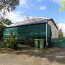
House, 94 Canning Highway, South Perth is representative of the type of housing constructed in the early twentieth century in the Metropolitan region; of the practice in the late nineteenth and early twentieth century where landowners bought property with intent to make profit; and of the residential development of South Perth, and in particular Canning Highway, during the early twentieth century.
House, 94 Canning Highway, South Perth, comprises a single storey brick and corrugated iron roofed building, concrete block garage with fibrous cement roof, and brick rendered WC, located on the corner of Canning Highway and Dyson Street in the city of South Perth. The front of the house faces towards Canning Highway. The street view is obscured by a 1.5m high painted brick fence and mature plantings. The single-storey house has a tuck-pointed face brick double frontage, which has been obscured by paint and additions either side of the front door. The side walls are of brick construction in stretcher bond. It has a simple hipped roof with gablets, constructed of corrugated metal sheeting. The front and rear additions have low-pitched skillion roofs clad with corrugated metal sheeting. The interior has timber flooring, hard plaster walls, and gyprock ceilings. The architraves are plain with splayed headers. There is a back-to-back fireplace in one of the bedrooms and in the lounge, which has an arched opening, painted pillow stone simple surround, and jarrah mantle. The kitchen is not original, apart from the plaster moulded mantel piece. The brick bathroom was likely added after 1960.
Three adjacent lots, including the land on which House, 94 Canning Highway, South Perth, is situated, were purchased in 1904 by Mr Andrew Janeczek, a well-known Goldfields pioneer of the time. The lots were transferred to Alexander Clydesdale in 1921. Clydesdale owned the lots between 1921 and 1925. The Certificate of Title shows that all three properties were transferred to separate owners in 1925. Lot 1 was transferred to a Thomas Daniel Prosser, builder, but it is not clear whether he occupied the premises. Post Office Directories indicate that there were five houses on this section of Canning Hwy (previously Fremantle Road) in 1927, but Prosser’s name is not evident. House, 94 Canning Highway, South Perth has had a number of private occupiers and owners after 1927.
Individual Building or Group
| Epoch | General | Specific |
|---|---|---|
| Original Use | RESIDENTIAL | Single storey residence |
| Present Use | VACANT\UNUSED | Vacant\Unused |
| Style |
|---|
| Inter-War California Bungalow |
| Type | General | Specific |
|---|---|---|
| Wall | BRICK | Common Brick |
| Roof | METAL | Steel |
This information is provided voluntarily as a public service. The information provided is made available in good faith and is derived from sources believed to be reliable and accurate. However, the information is provided solely on the basis that readers will be responsible for making their own assessment of the matters discussed herein and are advised to verify all relevant representations, statements and information.
95 Canning Hwy South Perth
Dyson Business Centre
South Perth
Metropolitan
Constructed from 1989
| Type | Status | Date | Documents |
|---|---|---|---|
| (no listings) |
| Type | Status | Date | Documents |
|---|---|---|---|
| (no listings) |
| Type | Status | Date | Grading/Management | |
|---|---|---|---|---|
| Category | ||||
| Local Heritage Survey | Adopted | 14 Nov 2000 | Category D | |
| Name | Type | Year From | Year To |
|---|---|---|---|
| Garry Baverstock | Architect | - | - |
Individual Building or Group
| Epoch | General | Specific |
|---|---|---|
| Original Use | SCIENTIFIC | Other |
| Present Use | SCIENTIFIC | Other |
| Style |
|---|
| Other Style |
| Type | General | Specific |
|---|---|---|
| Other | CONCRETE | Concrete Slab |
| Wall | CONCRETE | Reinforced Concrete |
| Roof | METAL | Steel |
| General | Specific |
|---|---|
| OTHER | Other Sub-Theme |
This information is provided voluntarily as a public service. The information provided is made available in good faith and is derived from sources believed to be reliable and accurate. However, the information is provided solely on the basis that readers will be responsible for making their own assessment of the matters discussed herein and are advised to verify all relevant representations, statements and information.
Constructed from 1989
• The place has aesthetic value as a good intact example of late twentieth century style incorporating solar design principles. • The place has historic value for its association with the development of environmental awareness in the Western Australian construction industry. • The place has social value as the first place for the public to gather information about solar energy. • The place has research value as one of the first examples of passive solar design in the metropolitan area.
The Solar Energy Advisory Centre (Former) is a long narrow rectangular building, with a truncated entrance at the street corner which reflects the angle of the street intersection. Although the address is Canning Highway, the building has a greater relationship with the secondary street, Dyson Street, rather than with the main highway. The building is of two storey reinforced concrete construction with additional rooftop accommodation for mechanical plant. The entrance to the building is below pavement level with steps down to the doorway and a ramp extending around the long edge of the structure. The two levels of the building present in a similar manner. The upper level incorporates a continuous band of recessed tinted aluminium framed windows, partially shaded by a louvered canopy. The lower level is similar, albeit with a mix of windows including full height windows, half height windows with panelling below and aluminium framed glass doors to both the main entrance and the side entrance on Dyson Street. All these windows are also protect by a louvered shade structure. The majority of the roof is obscured from view due to the parapet wall construction but is said to be a flat roof of “sandwich” construction on a steel frame. Being of an experimental nature and quite extensive, the functional mechanical elements of the building are exposed to the streetscape. The appearance of these elements has been treated as part of the architectural design of the building, which fits into the accepted model for an office structure.
The Solar Energy Advisory Centre (Fmr) was designed by architect Garry Baverstock (b.1949) a Perth-based architect, property developer, author and scientist, specialising in energy-efficient building design. In 1969, he founded the firm ‘Ecotect Architects’. He is Adjunct Professor and Built Environment Program Manager of the Research Institute of Sustainable Energy at Murdoch University, and became president of the International Solar Energy Society in Western Australia after holding the position of Honorary Secretary from 1979-1986. The concept of the Solar Energy Advisory Centre (Fmr) was to accommodate display and tenancy spaces in the building which, by means of passive solar design, achieve a high level of thermal performance and human comfort. The building was constructed for the same cost as a conventional office building of the same size, but uses 69% less energy. The building received the Australian Design Award in 1990. In 1993, it was awarded the Building category in the (then) Department of Primary Industries and Energy’s National Energy Awards. At the time, it was the only privately operated organisation in Australia to provide an information service to the public about solar energy in buildings. Since its construction the solar design elements of the design have been removed and replaced with air-conditoning and a standard metal deck roof.
High / High
Good
| Name | Type | Year From | Year To |
|---|---|---|---|
| Garry Baverstock | Architect | - | - |
| Ref ID No | Ref Name | Ref Source | Ref Date |
|---|---|---|---|
| Magazine: article- Solar Energy Information Centre Building, Perth. Solar Building No. 90. | "Solar Progress Renewable Energy for Australasia" Vol13, No2. | 1992 | |
| "The Australian" Newspaper | 14/10/1993 |
| Reserve | Lot/Location | Plan/Diagram | Vol/Folio |
|---|---|---|---|
| 50 | 74157 |
This information is provided voluntarily as a public service. The information provided is made available in good faith and is derived from sources believed to be reliable and accurate. However, the information is provided solely on the basis that readers will be responsible for making their own assessment of the matters discussed herein and are advised to verify all relevant representations, statements and information.
96 Canning Hwy South Perth
South Perth
Metropolitan
Constructed from 1925
| Type | Status | Date | Documents |
|---|---|---|---|
| (no listings) |
| Type | Status | Date | Documents |
|---|---|---|---|
| RHP - Does not warrant assessment | Current | 28 Jul 2017 |
| Type | Status | Date | Grading/Management | |
|---|---|---|---|---|
| Category | ||||
| (no listings) | ||||
• The place is representative of the type of housing constructed in the early twentieth century in the Metropolitan region.
• The place is representative of the practice in the late nineteenth and early twentieth century where landowners bought property solely as an investment.
• The place is representative of the residential development of South Perth, and in particular Canning Highway during the early twentieth century.
House, 96 Canning Highway, South Perth is a single storey timber framed weatherboard and corrugated iron roofed residence. The place is timber framed and covered in painted shiplap weatherboard. It has a simple hipped corrugated iron roof continuing in a skillion over the front verandah. There is single chimney constructed of face brick. There are Federation Bungalow influences with the place having a central door with adjacent double frontage elevation flanked by two sets of timber-framed windows. At the rear, there are the remains of a timber patio and a sleep-out addition. A small metal shed remains in the rear yard, adjacent to the northern fence.
Little development occurred in South Perth between 1829-1833 due to poor soil fertility, difficulty in travelling to and from Perth, and a large area of land being reserved toward the north for the purpose of a village. The establishment of a settlement in South Perth is not evident until c.1837, as shown on a survey by Alfred Hillman annotated by the name ‘Perth Suburban’. The South Perth Roads Board District formed in 1892, comprising the area bounded by Melville Water, Perth Water, Perth-Albany Road, Perth-Fremantle Road, and South Terrace. The first meeting of the South Perth Roads Board was held in the same year. In 1902 South Perth became a Municipality and the foundations of the Municipal Office were laid in 1904. At the turn of the twentieth century, South Perth began to be identified as a ‘fashionable locality’ after it experienced unprecedented development influenced by the gold rush of the 1890s, an influx of people escaping the depression in the eastern states, and following a modest housing boom in the area during the 1880s. Included in this development, and contributing to the area’s change of identity, was the construction of significant landmarks such as Perth Zoo.
Individual Building or Group
| Epoch | General | Specific |
|---|---|---|
| Original Use | RESIDENTIAL | Single storey residence |
| Style |
|---|
| Inter-War California Bungalow |
This information is provided voluntarily as a public service. The information provided is made available in good faith and is derived from sources believed to be reliable and accurate. However, the information is provided solely on the basis that readers will be responsible for making their own assessment of the matters discussed herein and are advised to verify all relevant representations, statements and information.
98 Canning Hwy South Perth
South Perth
Metropolitan
Constructed from 1925
| Type | Status | Date | Documents |
|---|---|---|---|
| (no listings) |
| Type | Status | Date | Documents |
|---|---|---|---|
| RHP - Does not warrant assessment | Current | 28 Oct 2016 |
| Type | Status | Date | Grading/Management | |
|---|---|---|---|---|
| Category | ||||
| (no listings) | ||||
• The place is representative of the type of housing constructed in the early twentieth century in the Metropolitan region.
• The place is representative of the practice in the late nineteenth and early twentieth century where landowners bought property with intent to make profit.
• The place is representative of the residential development of South Perth, and in particular Canning Highway, during the early twentieth century.
House, 98 Canning Highway, South Perth is representative of the type of housing constructed in the early twentieth century in the Metropolitan region; of the practice in the late nineteenth and early twentieth century where landowners bought property with intent to make profit; and of the residential development of South Perth, and in particular Canning Highway, during the early twentieth century.
House, 98 Canning Highway, South Perth is a single storey timber framed weatherboard and corrugated iron roofed residence on Canning Highway at the ‘T’ junction of Salisbury Avenue within the City of South Perth. The place is timber framed and covered in painted shiplap weatherboard. It has a simple hipped corrugated iron roof continuing in a skillion over the front verandah. There are two chimneys, the front chimney is painted face brick with corbelled detail topped with double clay pots and the rear chimney is similar in style but topped with a single clay pot. There are also Inter-War California Bungalow influences with the place having a central door with adjacent double frontage elevation flanked by two sets of timber-framed casement windows. An interior inspection of the place was not able to be undertaken.
Three adjacent lots, including the land on which House, 98 Canning Highway, South Perth, is situated, were purchased in 1904 by Mr Andrew Janeczek, a well-known Goldfields pioneer of the time. The lots were transferred to Alexander Clydesdale in 1921. Clydesdale owned the lots between 1921 and 1925. The Certificate of Title shows that all three properties were transferred to separate owners in 1925. The Certificate of Title shows that all three properties were transferred to separate owners in 1925. There are three names listed on this Certificate of Title, however, it is unclear which person took ownership of the land now comprising House, 98 Canning Highway, South Perth. The first mention of house in the Post Office Directories appears in 1926, with Alice Fernie listed as the inhabitant until 1936. Ms Fernie subsequently purchased the property in 1946 and it has had a number of private occupiers and owners after this period.
Individual Building or Group
| Epoch | General | Specific |
|---|---|---|
| Original Use | RESIDENTIAL | Single storey residence |
| Present Use | VACANT\UNUSED | Vacant\Unused |
| Style |
|---|
| Inter-War California Bungalow |
| Type | General | Specific |
|---|---|---|
| Wall | TIMBER | Weatherboard |
| Roof | METAL | Corrugated Iron |
| Other | TIMBER | Other Timber |
This information is provided voluntarily as a public service. The information provided is made available in good faith and is derived from sources believed to be reliable and accurate. However, the information is provided solely on the basis that readers will be responsible for making their own assessment of the matters discussed herein and are advised to verify all relevant representations, statements and information.
across Canning River South Perth
South Perth
Metropolitan
Constructed from 1982
| Type | Status | Date | Documents |
|---|---|---|---|
| (no listings) |
| Type | Status | Date | Documents |
|---|---|---|---|
| (no listings) |
| Type | Status | Date | Grading/Management | |
|---|---|---|---|---|
| Category | ||||
| Local Heritage Survey | Adopted | 14 Nov 2000 | Category C | |
Historic site
| Epoch | General | Specific |
|---|---|---|
| Original Use | Transport\Communications | Road: Bridge |
| Present Use | Transport\Communications | Road: Bridge |
| General | Specific |
|---|---|
| TRANSPORT & COMMUNICATIONS | Road transport |
This information is provided voluntarily as a public service. The information provided is made available in good faith and is derived from sources believed to be reliable and accurate. However, the information is provided solely on the basis that readers will be responsible for making their own assessment of the matters discussed herein and are advised to verify all relevant representations, statements and information.
Constructed from 1982, Constructed from 2006 to 2007
• The place has aesthetic value as a complex structure of a clean and simplicity of design using minimal materials that has been well integrated into the landscape. • The place has historic value for its association with the spread of the metropolitan area in the second half of the 20th century and the government support of extensive road systems and latterly rail systems. • The place has social value as it is a bridge that is well patronised by many members of the community for its function of enabling greater movement through the metropolitan area.
The Mount Henry Bridge carries the Kwinana Freeway across the Canning River below the heights of Mount Henry. The bridge was sensitively built, allowing for the retention of a wide strip of foreshore with its good spread of Nuytsia floribunda (Western Australian Christmas Tree) and the large and very old paperbarks in that area. The design of the Mount Henry Bridge allowed for a separate bicycle and pedestrian bridge to be cantilevered immediately below the traffic bridge. The original bridge is of post-tensioned concrete. It has nine spans with a total length of 660 metres and a deck width of 28.8 metres. In cross-section, it is a double box-section, with the upper deck carrying traffic and cantilevers at the bottom of the box carrying pedestrian / cycle paths. The bridge was constructed segmentally, using a balanced cantilever construction method. It carried three lanes of traffic in each direction, with two pedestrian / cycle paths on cantilevers at the lower level. At 660 metres long, the Mount Henry Bridge was the longest road bridge in Western Australia at the time it was built. The 2005 additions to the Mount Henry Bridge were constructed using an incremental launching technique, where 25-metre long segments were hydraulically jacked out onto piers from a casting bay on the southern embankment. The 26 reinforced segments were manufactured on site, and the launch of each segment took about five hours, scheduled two weeks apart throughout most of 2005. During construction, a combination of permanent and temporary piers were used. The appearance of the new bridge was designed to match the original bridge, with nine spans, the main navigation span at river level being 75 metres wide.
The north-south freeway system was planned by Professor Gordon Stephenson and Mr John Alastair Hepburn in 1955 as part of a plan to guide the long-term development of post-war Perth. Following the completion in 1959 of the Narrows Bridge, which had been planned independently of the Stephenson-Hepburn Plan, the remainder of the Freeway plan was adopted by the WA State Parliament in 1963. While the 1955 report had identified the location of the crossing of the Kwinana Freeway adjacent to Mount Henry, the 1963 Metropolitan Region Scheme showed the location as being adjacent to Deep Water Point. In 1967, following an objection from the City of Melville and consideration by the State Government of alternative crossing points, the location reverted to the Mount Henry side of the river, despite local concern about the environmental effect that this would have on the unspoilt shoreline of Mount Henry. Ultimately, in 1975, Parliament approved the MRPA’s recommendation and the Metropolitan Region Scheme was amended to show the crossing on the eastern side at Mount Henry. Stage 1 of the freeway extension resulted in the completion of the Canning Interchange in 1979. The second stage of the project involved the construction of the Mount Henry Bridge and the extension of the freeway to South Street. The Mount Henry Bridge was sensitively designed, and was constructed in such a way as to retain the foreshore of Mount Henry. The bridge was nearly twice the length of the Narrows Bridge, with separate pedestrian and cycle paths cantilevered below the main traffic lanes of the bridge. The construction contractor was Clough, and the project manager for Main Roads Western Australia was Geoff Smith. The official opening took place on 9 May 1982 with Premier Ray O’Connor and City of South Perth Mayor, George Burnett, in attendance. In 2005, further construction work commenced on a second Mount Henry Bridge as part of the widening of the Kwinana Freeway and to accommodate a two-way railway line. This was part of a new railway line located between the opposing traffic lanes of the Kwinana Freeway; and extending from the Perth central business district to Mandurah. The new 15 metre wide bridge was built to the west of the original Mount Henry Bridge. It was designed to carry an additional three lanes of traffic, a break-down lane and a cycle and walking path. The two bridges overlap but do not touch, appearing as one continuous structure. The railway is accommodated on the western side of the original bridge. Contractors were Leighton Constructions. The design team comprised Wyche Consultants, GHD and Coffey Geosciences. The new traffic bridge was opened to traffic in January 2006 and the southern suburbs railway commenced operation in 2007.
High / High
Good
| Ref ID No | Ref Name | Ref Source | Ref Date |
|---|---|---|---|
| Florey, Cecil. "Peninsular City: A Social History of the City of South Perth" | Angus and Robertson NSW | 1995 |
| Reserve | Lot/Location | Plan/Diagram | Vol/Folio |
|---|---|---|---|
| 1 | 12385 | LR3109-466 |
This information is provided voluntarily as a public service. The information provided is made available in good faith and is derived from sources believed to be reliable and accurate. However, the information is provided solely on the basis that readers will be responsible for making their own assessment of the matters discussed herein and are advised to verify all relevant representations, statements and information.
Carr St South Perth
South Perth
Metropolitan
| Type | Status | Date | Documents |
|---|---|---|---|
| (no listings) |
| Type | Status | Date | Documents |
|---|---|---|---|
| RHP - Does not warrant assessment | Current | 25 Feb 2005 |
| Type | Status | Date | Grading/Management | |
|---|---|---|---|---|
| Category | ||||
| (no listings) | ||||
Tree
| Epoch | General | Specific |
|---|---|---|
| Original Use | OTHER | Other |
This information is provided voluntarily as a public service. The information provided is made available in good faith and is derived from sources believed to be reliable and accurate. However, the information is provided solely on the basis that readers will be responsible for making their own assessment of the matters discussed herein and are advised to verify all relevant representations, statements and information.

Collins St South Perth
South Perth
Metropolitan
| Type | Status | Date | Documents |
|---|---|---|---|
| (no listings) |
| Type | Status | Date | Documents |
|---|---|---|---|
| (no listings) |
| Type | Status | Date | Grading/Management | |
|---|---|---|---|---|
| Category | ||||
| (no listings) | ||||
Individual Building or Group
| Epoch | General | Specific |
|---|---|---|
| Original Use | SOCIAL\RECREATIONAL | Other Community Hall\Centre |
| Present Use | SOCIAL\RECREATIONAL | Other Community Hall\Centre |
This information is provided voluntarily as a public service. The information provided is made available in good faith and is derived from sources believed to be reliable and accurate. However, the information is provided solely on the basis that readers will be responsible for making their own assessment of the matters discussed herein and are advised to verify all relevant representations, statements and information.
Coode St South Perth
South Perth
Metropolitan
Constructed from 1990
| Type | Status | Date | Documents |
|---|---|---|---|
| (no listings) |
| Type | Status | Date | Documents |
|---|---|---|---|
| (no listings) |
| Type | Status | Date | Grading/Management | |
|---|---|---|---|---|
| Category | ||||
| Local Heritage Survey | Adopted | 14 Nov 2000 | Category D | |
Historic Site
| Epoch | General | Specific |
|---|---|---|
| Present Use | Transport\Communications | Water: Jetty |
| Original Use | Transport\Communications | Water: Jetty |
| General | Specific |
|---|---|
| TRANSPORT & COMMUNICATIONS | River & sea transport |
This information is provided voluntarily as a public service. The information provided is made available in good faith and is derived from sources believed to be reliable and accurate. However, the information is provided solely on the basis that readers will be responsible for making their own assessment of the matters discussed herein and are advised to verify all relevant representations, statements and information.
Constructed from 1990, Constructed from 1896
The Coode Street Jetty is situated at the northern end of Coode Street in South Perth. This jetty was built in 1990 and is a simple timber deck construction with timber piles. The current jetty is in a different location and of a different design to the original jetty.
Prior to the construction of a jetty at this site in 1896, this location was regularly used as the landing site of boats for locals and visitors, including visiting clergy. Erected in 1896, the Coode Street Jetty was an important transport link to the Perth central business district. A map of South Perth produced by Real Estate Agents, Owtram and Purkiss in 1902, shows Coode Street Jetty as was one of three jetties on the south side of Perth Water, the other two being at Queen Street and Mends Street. In the early 1900s, boat building was a common local industry along the South Perth foreshore. One prominent local boat builder was A S Pritchard, who had a boat shed and residence in Swanview Terrace and hired out boats from the Coode Street Jetty. A ferry service between Perth and Coode Street, South Perth was first operated by W F Tubbs. The service was not a success and local residents, Rowland Pennington and Fred Bailey, formed a public company, the River Ferry Company, to try and bring some regularity to the system. Two sailing boats the Mary Queen and the Gladys were allocated to the service but the venture did not succeed. More successful was Roland Pennington’s kiosk which provided refreshments to commuters from an iron-clad kiosk set up by the Penningtons on their property on the corner of Coode Street and Suburban Road (now Mill Point Road). Each time a ferry docked, the kiosk was opened to provide such things as locally grown bananas split lengthways and filled with fresh cream. In 1904-6, a successful Swan River ferrying service was established by Jack Olsen and Claes (Harry) Sutton. This service including regular ferries to Coode Street. The fleet included the well-known ‘Val’ boats, such as Valfreda, Valthera, Valdemar and Valkyrie I and II were named in honour of Olsen’s and Sutton’s Scandinavian links. To enable the regular service to Coode Street, the jetty was modified in 1903 and in 1907. A 1916 timetable for Valdemar and Valdura showed a regular service to Coode Street ,seven days a week with costs for gentleman at 21 shillings per quarter with ladies being charged 12 shillings and sixpence per quarter. The Sutton and Olsen families continued the ferry service until 1935 when the business was sold to Nat Lappin who formed the Swan River Ferries Company. In contrast to the Coode Street ferry service, the government-operated Mends Street service raised many complaints. The Coode Street Jetty was used by Chinese market gardeners who occupied land on what is now Sir James Mitchell Park from the 1880s. At weekly intervals, the market gardeners packed their fresh produce on carts to take them across the Causeway to the James Street Markets in North Perth. Often on Saturday nights the hard-working gardeners would go by ferry across to Perth and have a night out on the town. They returned by the 11.30pm ferry and were back working by 6.00am the following morning. Until the 1940s, the South Perth foreshore was an irregular alignment with shallow reed beds on the waters edge. The state government, with local governments support, began a program of dredging and filling along the foreshore. As part of these works the Coode Street jetty was rebuilt out into the river on an alignment with Coode Street, where previously it was located to the east of Coode Street. It was proposed by the South Perth Road Board that a dredged pool located adjacent to the jetty prior to reclamation should be retained for swimming and boating. However the reclamation works meant this was not viable so the proposal did not proceed. A decline in passenger numbers led to the private Coode Street Ferry service transferring to the State transport system and the completion of the Narrows Bridge in 1959 was an additional factor in the decline the popularity of the ferry service. Since the 1960s, the future of the ferry service to Coode Street has a been regularly discussed. For a short period the ferry service between Barrack Street and Coode Street (via Mends Street) was suspended, and despite the rebuilding of the jetty in 1990, services were not reinstated. The new jetty was located west of the original jetty and did not have any building material from the earlier structure. In c1997, private company Captain Cook Cruises took over the contract for ferry services in Perth Water and as part of that served a limited ferry service to the Coode Street Jetty was offered. However, the ferry service to the Coode Street Jetty ended on 1 May 2005 due to lack of regular demand. At that time, the primary service to Mends Street had an average of about 24 passengers per trip, while the average number of patrons using the Coode Street stop was just three passengers per trip, consequently the service to the Coode Street Jetty was dropped. The jetty remains in situ and is used for passive recreation, fishing and by private boat owners as a location for short term berths and dropping and retrieving passengers.
High / High
Good
| Ref ID No | Ref Name | Ref Source | Ref Date |
|---|---|---|---|
| Florey, Cecil. "Peninsular City: A Social History of the City of South Perth" | City of South Perth WA | 1995 | |
| Dickson,R. The History of the South Perth Ferries in "South Perth-The Vanishing Village" | City of South Perth Historical Society WA | 2002 |
| Reserve | Lot/Location | Plan/Diagram | Vol/Folio |
|---|---|---|---|
| 34565 | 11835 | 240379 | LR3141-191 |
This information is provided voluntarily as a public service. The information provided is made available in good faith and is derived from sources believed to be reliable and accurate. However, the information is provided solely on the basis that readers will be responsible for making their own assessment of the matters discussed herein and are advised to verify all relevant representations, statements and information.
Coode St South Perth
South Perth
Metropolitan
| Type | Status | Date | Documents |
|---|---|---|---|
| (no listings) |
| Type | Status | Date | Documents |
|---|---|---|---|
| (no listings) |
| Type | Status | Date | Grading/Management | |
|---|---|---|---|---|
| Category | ||||
| Municipal Inventory | Adopted | 28 Feb 1996 | Category E | |
| Library Id | Title | Medium | Year Of Publication |
|---|---|---|---|
| 9935 | Electricity generation, transmission and distribution in Western Australia: representation on the register of heritage places. | Report | 2007 |
Historic Site
| Epoch | General | Specific |
|---|---|---|
| Original Use | GOVERNMENTAL | Power Station |
| Present Use | GOVERNMENTAL | Power Station |
| General | Specific |
|---|---|
| SOCIAL & CIVIC ACTIVITIES | Government & politics |
This information is provided voluntarily as a public service. The information provided is made available in good faith and is derived from sources believed to be reliable and accurate. However, the information is provided solely on the basis that readers will be responsible for making their own assessment of the matters discussed herein and are advised to verify all relevant representations, statements and information.
Site
This information is provided voluntarily as a public service. The information provided is made available in good faith and is derived from sources believed to be reliable and accurate. However, the information is provided solely on the basis that readers will be responsible for making their own assessment of the matters discussed herein and are advised to verify all relevant representations, statements and information.
Coode St South Perth
South Perth
Metropolitan
Constructed from 1912
| Type | Status | Date | Documents |
|---|---|---|---|
| (no listings) |
| Type | Status | Date | Documents |
|---|---|---|---|
| (no listings) |
| Type | Status | Date | Grading/Management | |
|---|---|---|---|---|
| Category | ||||
| (no listings) | ||||
Individual Building or Group
| Epoch | General | Specific |
|---|---|---|
| Present Use | SOCIAL\RECREATIONAL | Other Community Hall\Centre |
| Original Use | SOCIAL\RECREATIONAL | Other Community Hall\Centre |
This information is provided voluntarily as a public service. The information provided is made available in good faith and is derived from sources believed to be reliable and accurate. However, the information is provided solely on the basis that readers will be responsible for making their own assessment of the matters discussed herein and are advised to verify all relevant representations, statements and information.
20 Coode St South Perth
South Perth
Metropolitan
Constructed from 1923 to 2000
| Type | Status | Date | Documents |
|---|---|---|---|
| Heritage List | Adopted | 14 Nov 2000 | |
| State Register | Registered | 25 Aug 2009 | HCWebsite.Listing+ListingDocument, HCWebsite.Listing+ListingDocument |
| Type | Status | Date | Documents |
|---|---|---|---|
| (no listings) |
| Type | Status | Date | Grading/Management | |
|---|---|---|---|---|
| Category | ||||
| Statewide War Memorial Survey | Completed | 01 May 1996 | ||
| Art Deco Significant Bldg Survey | Completed | 30 Jun 1994 | ||
Generally, all buildings on site are in good and sound structural condition. The buildings have been well maintained and well utilised. There is an ongoing conservation works program repoint brickwork and replace roof tiles in J.F. Ward Wing and J.S. Maloney House. Extensive conservation works to the structure of Wesley College Old Boys' Memorial Chapel have also been carried out. The place has a high degree of integrity, having been in continuous use as a school since its establishment in 1923. Most buildings are still used for their intended purpose, although the earliest classrooms are not longer used as such, and neither the 1923 nor the 1937 headmaster's accommodation retain a residential function. The original forms and built fabric of the Inter-War buildings are largely intact. Efforts have been made to ensure that all new additions are carried out in a sympathetic manner, keeping to the established forms, palette of materials, and colours. Though extensive refurbishment works have been carried out internally in these buildings, the original planning is largely intact. Overall, the authenticity of the place and individual buildings on site remains moderate to high.
| Name | Type | Year From | Year To |
|---|---|---|---|
| Ross Chisholm (chapel) | Architect | 1960 | 1960 |
| James Hine | Architect | 1923 | 1928 |
| Hobbs, Forbes & Partners | Architect | 1947 | 1947 |
| John Flower | Architect | 1996 | 1997 |
| Forbes & Fitzharding | Architect | 1962 | 1978 |
| Eales, Cohen & Fitzharding (gym) | Architect | 1940 | 1940 |
| Library Id | Title | Medium | Year Of Publication |
|---|---|---|---|
| 9547 | Honest and unsullied days: a history of Wesley College, Perth. | Book | 2001 |
Individual Building or Group
| Epoch | General | Specific |
|---|---|---|
| Present Use | EDUCATIONAL | Secondary School |
| Original Use | EDUCATIONAL | Secondary School |
| Style |
|---|
| Inter-War Georgian Revival |
| Post-War Ecclesiastical |
| Inter-War Gothic |
| Federation Arts and Crafts |
| Type | General | Specific |
|---|---|---|
| Roof | TILE | Terracotta Tile |
| Other | METAL | Other Metal |
| Wall | BRICK | Common Brick |
| General | Specific |
|---|---|
| SOCIAL & CIVIC ACTIVITIES | Community services & utilities |
| OUTSIDE INFLUENCES | World Wars & other wars |
| SOCIAL & CIVIC ACTIVITIES | Education & science |
| DEMOGRAPHIC SETTLEMENT & MOBILITY | Land allocation & subdivision |
| SOCIAL & CIVIC ACTIVITIES | Religion |
This information is provided voluntarily as a public service. The information provided is made available in good faith and is derived from sources believed to be reliable and accurate. However, the information is provided solely on the basis that readers will be responsible for making their own assessment of the matters discussed herein and are advised to verify all relevant representations, statements and information.
Constructed from 1923
The following statement is drawn from the Register Entry for Place 2379 Wesley College, South Perth prepared in 2009. Wesley College, South Perth, a school complex comprising two storey brick and tile J. F. Ward Wing (1923), Kefford Wing (1925, 1936, 1957-58, 1962-64), J. S. Maloney House (1937) Clive Hamer Building (1940), and H. R. Trenaman Library and Staff common building (1937, 1970); double volume concrete and metal Old Boys’ Memorial Chapel (1961); Old Wesley Collegians’ Association Memorial Lych Gate (1953) and Rose Garden (1995); J. F. Ward Oval (1924); and, Jenkins Quadrangle (1978), set in landscaped gardens of grass, shrubs and established trees, has cultural heritage significance for the following reasons: • the place illustrates aspects of the development of education in Western Australia and is valued by the community of South Perth, the Methodist community and the wider community for its contribution to the education of generations of boys; • Wesley College Old Boys’ Memorial Chapel is a fine representative example of Post War Ecclesiastical style, featuring innovative design and building techniques through the use of reinforced concrete ring beams and precast concrete walls and slabs, built to an award-winning 1960 design by Ross Chisholm; • the place is a cohesive complex of educational buildings, developed from the 1920s to the present (2007) in a manner which, on the whole is architecturally sympathetic to earlier elements; • the place contributes to the community’s sense of place as it has been in the same locality and performing similar educational functions since 1923, during which time the suburb of South Perth has developed around the school and the place has become an intrinsic part of the streetscape and community; and, • the individual elements of the place collectively form an attractive cultural landscape of significant buildings and structures set within an accessible, inviting and pleasing landscape.
Wesley College occupies a 19 hectare site on the ridge of the foreshore escarpment with. View towards the river and the city. The site generally bounded by Mill Point Road, Coode Street, Angelo Street, Tate Street and Leane Street, South Perth. The site comprises three precincts, the Heritage Precinct on the western side of the site, the Senior School Precinct on the eastern side and the Swan Street Precinct, comprising the central section of the school complex. The buildings within the Heritage Precinct are: JF Ward Wing, (1923) – two storey fair face brick with rendered banding displaying elements of the Federation Arts and Crafts style. Originally designed as a single storey three winged building, the upper level was added in 1927 and two single storey additions were constructed between the wings. The original main entrance is on the north façade which has a two storey verandah supported by face brick columns with roughcast panels in between, a clapboard clad two storey bay window in the centre and a gable end punctuated by three double hung sash windows on each level of the east end of the façade. An escape ladder made from a series of steel rungs from WWII remains extant on the brick verandah column. The west elevation with its three prominent gable ends to the wings is set back from Coode Street in a garden setting overlooking the Rose Memorial Garden. Each façade to wings is composed of alternating red face brick columns and rough cast rendered panels above which each of the double hung sash windows are placed. The intersection between the levels is concealed and articulated with a rendered band and stringcourse. The gables are finished in roughcast render with brick panel at the apex. The central wing has terracotta shingled awnings to both levels of windows. Two double height skillion additions have been added between the wings, projecting out into the garden. The upper section is clad with louvers whilst the lower level is open to three sides. Each provides sheltered access into the building. Kefford Wing (1925) – a two storey brick and tile building comprising of two “L” shaped windows with a centrally placed two-storey addition to the north and south elevations. The wing was originally constructed as a single storey single wing building. A second wing mirroring the design of the first was later added followed by additional storeys. The face brick walls are supported by a series of brick buttresses with rendered capping. The original south façade has been partially obscured by the construction of a double height enclosed walkway and reception area. The original features of the façade remain extant and now form part of the internal space. The original timber framed sashes with rendered surrounds are now a feature of this space. Much of the original north elevation has become obscured by a continuous concrete and glass enclosed corridor which connects all the buildings around the Jenkins Quadrangle. JS Maloney House (1937) – two storey brick and tile former Headmaster’s residence and marks the boundary of the original school site. The former house has a symmetrical façade to the north elevation with a central porch entry. The porch has a brick paved floor, openings on the east and west elevations with brick steps and a large centrally placed opening featuring a pair of columns in the Tuscan order and steel balustrading between. All openings feature modern details expressed through lintels of vertically placed bricks and supported by flat steel lintels. Above the porch is an enclosed room with large glazed openings. A corbelled feature on the eastern end of the front façade adds a whimsical touch to the formal façade. On the west elevation the window of the front room has shitter stays which are still extant but no shutters. There is a brick paved verandah approximately mid length of the house, between the front room and the rear rooms. French doors open out onto the verandah. The south elevation overlooks the Rose Memorial Garden has an informal arrangement of windows and roof forms featuring a pair of small dormers and deep eaves against hipped roofs over the main area of the house. The south west corner of the house has been extended and re-roofed with its own hip. A skillion verandah canopy supported on square posts wraps around the south and east elevation. the ground level openings to these two elevations have been altered to incorporate full height windows and sliding doors which has impacted on the aesthetics of the building. Old Wesley Collegians Association Memorial Lych Gate (1953) – a rectilinear structure constructed of limestone blocks and timber stop chamfered posts supporting a terracotta shingled gable roof. It is orientated on a north-south axis. The Wesley College coat of arms is featured on the north and south elevations. Internally there are two integral timber slatted benches and two brass plaques engraves with names of Old Boys who lost their lives during various war. Each name is also represented by a cardinal rose bush in the adjacent Memorial Roe Garden. Rose Garden – cruciform garden containing 56 roses forming an emotive and attractive feature of the west boundary of the school site. Wesley College Old Boys’ Memorial Chapel (1961) the Memorial Chapel is designed in the Post War Ecclesiastical style featuring reinformed concrete ring beams, precast concrete walls and slabs. It is a cylindrical building elevated on a square terrazzo paved podium with a steel portico on the southern side. The roof comprises a series of 12 steel framed sheet metal clad apexes and valleys, surmounted in the entre by a tall steel spire. Each steel valley rafter functions as a gutter draining into 12 strategically located circular pipe columns. Precast concrete panels with exposed aggregate finish are alternated with panels of cement render finish to create a play of dark and light tones on the façade. Alternate panels are set back from the edge of the ring beam to allow for an insert of steel framed louvered glass windows. The congregation enters the Chapel on the south side by means of a small flight of steps onto the elevated terrazzo paved podium through a pair of glazed double doors with vertical glazing bars and into the narthex. There is an alternative eastern side entrance with similarly detailed double doors. HR Trenaman Library (1937) – this building was designed as a single storey brick and tile dining and assembly hall in 1937 with the second storey being added in 1970. The building presents with Inter-War Georgian Revival Characteristics. The ground floor is constructed of red/brown toned brickwork laid in stretcher bond with large openings with three leaded light sash widows to each adding light and formality to the structure. The windows are surrounded by rendered and scribed surrounds installed to replicate quoining. The main entrance is on the wet elevation overlooking the Jenkins Quadrangle, with a single step access. The entrance has ornate plaster moulding and timber double doors. The upper level is obscured from clear view due to the enclosed concrete and glass walkway but it is of face brick construction with large square steel framed openings. Clive Hamer Building (1940) is located in the Senior School Precinct but contributes to the brick built structures of the early buildings and displays characteristics of the Inter-War Georgian Revival and Inter-War Gothic Revival styles. The interior has been adapted and was undergoing further works in January 2018. The south elevation overlooking the Ward Oval is composed of the original four centred pointed arch arcade on the ground floor. There are five large openings with rendered surrounds on the recessed section of the upper floor and both gable ends incorporate two sets of windows, each containing three aluminium framed sashes in a rendered surround. The north elevation almost replicates the south elevation. the recessed section contains the arched openings and the windows in the same manner as the south façade. The eastern gable has three levels of windows including one in the apex of the gable. The western gable has a four-centred arched doorway opening and a single sash window above.
The first Methodist settlers had arrived in the Swan River Colony in 1830. Wesleyan Methodism is associated with the beginnings of education in Western Australia. The first Wesleyan primary school in Perth opened c1835 and provided education services for approximately one quarter of all children enrolled in the colony, not just Methodist children. The Methodist population of Western Australia had increased with immigration from the eastern states following the gold rushes of the 1890s. By the beginning of World War One, the need for a new Wesleyan school was recognised, in particular to meet the needs of farmers’ children requiring city education following several years of rural drought. A Boys’ College Committee, formed in 1916, chose a 9 acre (3.6 ha) site on a ridge overlooking the river in South Perth, purchased in 1919 for £1450. The earliest buildings at Wesley College were designed by architect James Hine, a Methodist parishioner and prominent architect. Hine prepared plans for a single storey E-shaped building, consisting of a headmaster’s residence, dormitory accommodation for up to 25 boarders, and classroom space for around 100 students which was to double as a place for public worship for South Perth Methodists. The foundation stone for the original building was laid on 11 November 1922, by Premier Sir James Mitchell, who declared his opinion that, ‘the boy with the trained, flexible mind made a good farmer’. The building contractor employed to realise Hine’s design was M. Ellyard. Classes commenced on 13 February 1923 and at that time the South Perth area was populated by under three thousand residents. The streets were largely unsealed, much of the surrounding bushland was undeveloped, and public health amenities such as sewerage were yet to arrive. During the 1920s the local population boomed, and the construction of Wesley College represented a major building project in the burgeoning suburb of South Perth. The first headmaster of Wesley College, John Frederick Ward, served from 1923 to 1929. The first class consisted of day scholars from South Perth and surrounding suburbs, and boarders from towns in the Wheatbelt and Great Southern districts. Almost immediately plans were formulated to improve the grounds and add new buildings. A second storey was added in 1927, and, with several new timber single storey buildings, met the need for additional dormitory and classroom space. The work was undertaken by builder A. L. Toms. A plan of the site in 1936 shows that Wesley College, South Perth consisted of two brick buildings; the original building (Ward) and a single-storey classroom on the location of the western part of Kefford. On the remainder of the site were timber and asbestos buildings. The second headmaster, James Leonard Rossiter, served from 1930 to 1952. In 1936, Rossiter moved to rental accommodation off-campus, freeing up rooms for school use. However, the school continued to expand and architects Hobbs, Forbes & Partners were commissioned to produce a master plan for the school. The priorities were to provide a headmaster’s residence and a new block containing classrooms, dining hall, and kitchen, with the buildings to face south with an imposing façade overlooking the oval and Angelo Street entrance. The first stage of the plan involved a single storey building containing classrooms, and a dining hall, defining the south and east sides of a central quadrangle, with provision for addition of second storey extensions. The new dining hall and classrooms were opened on 18 September 1937, by Professor Walter Murdoch. A notable feature of the new dining hall was the stained glass window at the southern end, designed by Wesley Old Boy Arnold Camerer. Also during 1937, the new headmaster’s residence designed by Hobbs and Forbes was completed. The gymnasium (later named the Hamer building) was built during 1940. In the lower level an open undercroft provided a space for boxing contests. This building was designed by architects Eales Cohen and Fitzhardinge. During 1950, the water tower (a well-known local landmark) was removed to make way for extensions to the gymnasium which comprised new changing rooms at the lower end and a new classroom block at the upper end. In 1950, the oval in front of the main building, which had been rolled and planted by staff and students in 1924, was named J. F. Ward Oval after the first headmaster. The Rossiter Oval was named at the same time after the second headmaster. The memorial lych-gate and rose garden, commemorating the 55 former students killed during World War II, was opened in July 1953. The third headmaster, N. R. (Roy) Collins, served from 1953 to 1964 and oversaw future expansion of the college through the acquisition of properties along adjacent streets and the completion of several building projects. The new buildings included a new physics and chemistry labs and undercroft change rooms (1955-56); three new classrooms were added above the old third-year classrooms during 1957-58 (now part of the Kefford wing); a second section of the science building, devoted to biology and manual arts (1958-59) and the Junior boarding house, at the corner of Swan Street and Coode Street, was opened in 1959. The opening of the Narrows Bridge (1959) and Kwinana Freeway encouraged the development of South Perth, Como, and the surrounding suburbs. New southern suburbs such as Rossmoyne and Booragoon provided a wider catchment area for Wesley College. Students increasingly came from non-denominational families. Plans for a chapel finally came to fruition with the construction of the Memorial Chapel during 1960. Old Boy and architect, Ross Chisholm won a competition for the design with a building noted for its innovative and contemporary use of concrete ring beams and precast slabs. The chapel was built by L. Lilleyman Pty. Ltd. In 1962, architects Forbes and Fitzhardinge designed part of the second storey extensions to the existing classroom block which subsequently became the Kefford Wing. A new Olympic-size swimming pool was opened on 27 April 1963. The pool became available for use by the general public. Over the summer of 1963-64, three classrooms built during 1926 were demolished, to make way for a new building comprising six classrooms on two levels, at the western end of the main classroom block (named the Kefford Wing in 1998). The fourth headmaster, Clive Hamer, served from 1965 to 1983. In 1968, plans were prepared by Forbes and Fitzhardinge for the final second storey addition of the Kefford building. At the same time the covered walkway with concrete pillars was added to the Kefford building. The Trenaman Library was built in 1970, over the old dining hall. The foundation stone for the Joseph Green Centre was laid on the 13th February 1973. The Centre, comprising an assembly hall, performing arts space, lecture theatre, and Old Boys’ room, opened in 1974 to commemorate the fiftieth anniversary jubilee of Wesley College. Wesley College became partly co-educational from the late 1970s. In this period the Methodist, Congregational, and Presbyterian Churches amalgamated into the Uniting Church of Australia. A new preparatory school facing the south side of Swan Street was designed by Tony Brand, of Forbes & Fitzhardinge, and constructed by Cooper & Oxley. It was opened on 25 March 1978 by Premier Sir Charles Court. Further additions were undertaken to the original building in 1978 the most significant being the addition of the upper level walkway. This design was prepared by architects Forbes and Fitzhardinge. The fifth headmaster, Roderick Edward Kefford, served from 1984 to 1996. Over summer 1984 to 1985, squash courts in Tranby boarding house were converted into dormitories. Also in 1985 construction began on the Robert Blanckensee Physical Education Centre which was completed in 1987. The opening of the Blanckensee Centre allowed redevelopment of the gymnasium (built 1940) as senior school classrooms. The refurbished building, named the Hamer Building after the former headmaster, opened on 2 July 1989. Four houses, one on Coode Street, and three on Mill Point Road, were demolished in late 1992 to make way for a preparatory school resource centre, which was opened on 10 April 1994 by Premier Richard Court. By 1995, over a third of boarders were full fee paying overseas students, often from families practising Islam. Wesley College has shifted its client base over its history, from the original students from mainly lower middle-class families practising Methodism, through to the more affluent families of mixed religious affiliations who moved into the southern suburbs from the 1950s onward, to the multicultural student body of recent decades. The place reflects the broad demographic shifts in the surrounding area. A new design and technology building was completed in 2004 and in the following year the Memorial Lych Gate was relocated. The site is constantly being assessed for the school’s future needs and developed in response to these changing needs. The school administrators have sympathy for the heritage buildings on the site and the new buildings on the site have been designed sympathetically to the existing buildings.
High / Moderate
Good
| Name | Type | Year From | Year To |
|---|---|---|---|
| Eals, Cohen & Fitzharding (Gym) | Architect | 1940 | 1940 |
| Hoobs, Forbes & Partners | Architect | 1947 | 1947 |
| Ross Chrissholm (chapel) | Architect | 1960 | 1960 |
| J. Flower | Architect | 1996 | 1997 |
| Forbes & Fitzharding | Architect | 1962 | 1978 |
| J. Hine | Architect | 1923 | 1928 |
| Ref ID No | Ref Name | Ref Source | Ref Date |
|---|---|---|---|
| Florey, Cecil. "Peninsular City: A Social History of the City of South Perth" | City of South Perth WA | 1995 | |
| "Cosmopolitan Past for Old Bell Tower" in "Southern Gazette" page page 32 | 16/5/1995 | ||
| Historical Notes | Provided by Barbara van Bronsijk, Wesley College Archivist | 1998 |
| Reserve | Lot/Location | Plan/Diagram | Vol/Folio |
|---|---|---|---|
| 504 | 27361 | 1686-383 |
| Owner | Category |
|---|---|
| Welsey College | Other Private |
This information is provided voluntarily as a public service. The information provided is made available in good faith and is derived from sources believed to be reliable and accurate. However, the information is provided solely on the basis that readers will be responsible for making their own assessment of the matters discussed herein and are advised to verify all relevant representations, statements and information.
43 Coode St South Perth
South Perth
Metropolitan
| Type | Status | Date | Documents |
|---|---|---|---|
| (no listings) |
| Type | Status | Date | Documents |
|---|---|---|---|
| (no listings) |
| Type | Status | Date | Grading/Management | |
|---|---|---|---|---|
| Category | ||||
| (no listings) | ||||
Council advised that fmr Wesley Tuckshop was removed from the MI and demolished c1996.
Individual Building or Group
| Epoch | General | Specific |
|---|---|---|
| Original Use | COMMERCIAL | Shop\Retail Store {single} |
| Present Use | RESIDENTIAL | Single storey residence |
This information is provided voluntarily as a public service. The information provided is made available in good faith and is derived from sources believed to be reliable and accurate. However, the information is provided solely on the basis that readers will be responsible for making their own assessment of the matters discussed herein and are advised to verify all relevant representations, statements and information.
91 Coode St South Perth
Michelangelos
South Perth
Metropolitan
| Type | Status | Date | Documents |
|---|---|---|---|
| Heritage List | Adopted | 25 Sep 2018 |
| Type | Status | Date | Documents |
|---|---|---|---|
| (no listings) |
| Type | Status | Date | Grading/Management | |
|---|---|---|---|---|
| Category | ||||
| (no listings) | ||||
Individual Building or Group
| Epoch | General | Specific |
|---|---|---|
| Original Use | COMMERCIAL | Shop\Retail Store {single} |
| Present Use | COMMERCIAL | Other |
| Other Use | RESIDENTIAL | Single storey residence |
| Style |
|---|
| Inter-War Stripped Classical |
| Type | General | Specific |
|---|---|---|
| Roof | METAL | Zincalume |
| Wall | BRICK | Painted Brick |
| General | Specific |
|---|---|
| DEMOGRAPHIC SETTLEMENT & MOBILITY | Settlements |
| OCCUPATIONS | Commercial & service industries |
This information is provided voluntarily as a public service. The information provided is made available in good faith and is derived from sources believed to be reliable and accurate. However, the information is provided solely on the basis that readers will be responsible for making their own assessment of the matters discussed herein and are advised to verify all relevant representations, statements and information.
Constructed from 1960, Constructed from 1922
• The place has aesthetic value as a good, largely intact demonstration of an Inter War shop and premises executed in brick and iron which retains original detail. Internal details that remain from the original construction are likely to reflect this style. • The place has historic value for its association with the development of South Perth in the Inter War years and the provision of commercial services to the local community. • The place has social value for its demonstration of the scale and form of a typical shop and premises built in the Inter War period which demonstrates the scale of housing for working families. • The place has social value for its association with well-known local businessman Silvio Wirth-Pagnamenta who has contributed to the local community for nearly 40 years.
A typical inter-war corner shop and house combination overlooking Coode Street and Hensman Street. The house extended to the south of the shop and the asymmetric planning of the shop made it a prominent feature of the streetscape, opening directly onto the street. The shop has a direct relationship with the intersection, the angled element of the façade opening towards the confluence of Hensman and Coode Streets. The entrance to the shop was splayed, with windows on the angled walls and the main store windows on the flat sections of the elevations to Hensman Street and Coode Street. the arrangement has been retained by the windows and doors have been altered. The configuration of the four small highlight windows above the main shop windows remain extant but have been infilled. The main decorative element of the shop frontage is the majestic parapet wall. The extent of the parapet coincides with the glazed elements of the frontage, gradually stepping up until it culminates in an arched pediment above the entrance. The parapet is of rendered brick construction with prominent decorative cement capping to the wall and columns. The remainder of the frontage is painted brick. A non-original canopy wraps around the store frontage. The hipped roof to the residence together with faceted hip of the shop have been reclad with zincalume.
This portion of South Perth was subdivided for residential lots in 1894 however it was not significantly developed until after World War One when there was a period of rapid growth. The population in the district rose from 3,000 people in 1921 to nearly 9,000 in 1933. Between 1920 and 1930 a number of schools, churches, theatres and hotels developed to serve the growing communities in the district. It was logical therefore that commercial enterprises were established during this period. From the readily available information this place was built c1922 to serve as a shop and premises. The owner and builder of the place have not been determined however the first occupant was draper and grocer Bertie Blackburn and his wife Rachel Blackburn, nee Stone. The couple had married in 1921 and they lived at this place for several years establishing commonly known as a 'mixed business'. Later store managers were; Mrs Elizabeth Guy, Mrs Linda Narroway, H. Willcocks, and a long term manager and resident was John Stephen Foxwell and his wife Kathleen, nee Duffy. The Foxwell's lived at the premises and operated the mixed business from the mid 1940s until the mid 1950s. In the 1960s to 1970s, the place was one of the Foodland chain of small grocery stores. The place was used as a corner store and residence until the current tenant took up occupancy in 2002. The place was refurbished for use as a hair salon and the former residence was also adapted for a commercial use. The Hair Salon (Michelangelo) has had a long association with South Perth as the previous premises were established in 1979 at 74 Angelo Street, which provided the origin of the business name. The business owner Silvio Wirth-Pagnamenta, and staff have therefore been serving the South Perth community for nearly 40 years. Aerial photographs indicate the form and extent of the building have not changed significantly since the mid 20th century. The addition to the western side of the building appears to date from the early 1960s although further research may resolve this query.
Moderate / High
Good
| Ref ID No | Ref Name | Ref Source | Ref Date |
|---|---|---|---|
| Wises Post office Directories 1894-1949. | |||
| Australian Electoral Rolls, 1903-1981. | |||
| Landgate Aerial photographs 1948-2017 | |||
| Draft documentation Local Heritage Inventory 2005, Place SPCv10 |
| Reserve | Lot/Location | Plan/Diagram | Vol/Folio |
|---|---|---|---|
| 1 | 929 | 235-46A |
This information is provided voluntarily as a public service. The information provided is made available in good faith and is derived from sources believed to be reliable and accurate. However, the information is provided solely on the basis that readers will be responsible for making their own assessment of the matters discussed herein and are advised to verify all relevant representations, statements and information.

99 Coode St South Perth
Residence
St John Ambulance Station
South Perth
Metropolitan
Constructed from 1935
| Type | Status | Date | Documents |
|---|---|---|---|
| Heritage List | Adopted | 14 Nov 2000 |
| Type | Status | Date | Documents |
|---|---|---|---|
| (no listings) |
| Type | Status | Date | Grading/Management | |
|---|---|---|---|---|
| Category | ||||
| Fire & Rescue Service Heritage Inventory | Adopted | 30 Aug 1997 | ||
| Name | Type | Year From | Year To |
|---|---|---|---|
| Catherine & Murray Cox (adaptive works for residential use) | Architect | - | - |
Individual Building or Group
| Epoch | General | Specific |
|---|---|---|
| Other Use | HEALTH | Other |
| Original Use | GOVERNMENTAL | Fire Station |
| Present Use | RESIDENTIAL | Single storey residence |
| Style |
|---|
| Inter-War Free Classical |
| Type | General | Specific |
|---|---|---|
| Wall | BRICK | Rendered Brick |
| Roof | TILE | Terracotta Tile |
| General | Specific |
|---|---|
| SOCIAL & CIVIC ACTIVITIES | Community services & utilities |
This information is provided voluntarily as a public service. The information provided is made available in good faith and is derived from sources believed to be reliable and accurate. However, the information is provided solely on the basis that readers will be responsible for making their own assessment of the matters discussed herein and are advised to verify all relevant representations, statements and information.
Constructed from 1936, Constructed from 1937, Constructed from 1988
The former Fire Station is a single storey building of domestic scale and sits comfortably amongst the surrounding residential development. The place has been adapted for residential use which resulted in some changes to the presentation of the place. The building has an asymmetric plan form with a central projecting bay containing the main entrance and two flanking recessed sections creating a form of symmetry to the main section of the façade. The symmetry is off balanced by a corner verandah to the north east corner of the front elevation. All visible window openings are non-original and are now characterised by glass blocks allowing light into the building but limiting visual access. The pair of vehicle doors that were located in the projecting bay have been replaced with a recessed entrance and glass block window which has removed the fire station character from the building. The words “Fire Station” originally extended across the two rendered panels above the vehicle doors but these have been removed. The original face brick gas been rendered over obscuring the brick bond, the soldier bricks at eaves height and the rendered lintels to the façade openings. The roof is formed by a series of hips, clad with terracotta tiles and the chimney has been removed.
The site for the former South Perth Fire Station in Coode Street, previously identified as Lots 12 and 13, was purchased in 1934 for £75 by the Fire Brigades Board to replace the inadequate and rundown station on the corner of Suburban (Mill Point) Road and Onslow Street. A tender for £2,178 was accepted from contractor W.T. Clark for the construction of the Coode Street Fire Station, and construction was undertaken in 1935. The architect for the station was Ken Duncan who was the honorary architect for the WA Fire Brigades from many decades. In January 1936, the Fire Station was opened by the Minister for Lands, William Henry Kit son MLC, with Chairman of the Road Board, George Vincent Abjornson presiding over the ceremony and Mrs Abjornson unlocking the station doors. In 1937, an error in the construction was revealed when it was discovered the Fire Station had inadvertently been built on Lots 13 and 14 (instead of 12 and 13). This discovery resulted in a land swap with the owner of Lot 14, Mr A Power, who was given Lot 12 in place of Lot 14. The lots occupied by the Fire Station were later amalgamated and the site is now identified as Lot 102. The Fire Station operated until 1973, when it was closed and its functions were replaced by a new Fire Station in George Street, Kensington. This building was subsequently used as a St John’s Ambulance station until 1987 when it was transferred to private owners. The building was converted by architect Murray Cox into a residence for his own family. The conversion to a modern dwelling was recognised and awarded. Previously the building consisted of two cottages, separated by two large garages. The cottages were converted into living accommodation, one for adults, one for children, while the garages in between became communal living rooms. The basic internal structure was not significantly modified. The place continues to be used as a private residence and aerial photographs indicate the form and extent of the original building have not changed significantly since construction.
Low / Moderate
Good
| Name | Type | Year From | Year To |
|---|---|---|---|
| Ken Duncan | Architect | - | - |
| C & M Cox | Architect | - | - |
| Ref ID No | Ref Name | Ref Source | Ref Date |
|---|---|---|---|
| Wises Post office Directories 1894-1949 | |||
| The West Australian | 27 July 1935 | ||
| Taylor, Dr John J., ‘Kenneth Charles Duncan (1898-1983)', Western Australian Architect Biographies, http://www.architecture.com.au/ | |||
| The West Australian | 17 Jan 1936 |
| Reserve | Lot/Location | Plan/Diagram | Vol/Folio |
|---|---|---|---|
| 102 | 61175 | 1593-271 |
This information is provided voluntarily as a public service. The information provided is made available in good faith and is derived from sources believed to be reliable and accurate. However, the information is provided solely on the basis that readers will be responsible for making their own assessment of the matters discussed herein and are advised to verify all relevant representations, statements and information.
80 Douglas Av South Perth
South Perth
Metropolitan
| Type | Status | Date | Documents |
|---|---|---|---|
| (no listings) |
| Type | Status | Date | Documents |
|---|---|---|---|
| RHP - Does not warrant assessment | Current | 27 Mar 1998 |
| Type | Status | Date | Grading/Management | |
|---|---|---|---|---|
| Category | ||||
| (no listings) | ||||
Individual Building or Group
| Epoch | General | Specific |
|---|---|---|
| Present Use | RESIDENTIAL | Single storey residence |
| Original Use | RESIDENTIAL | Single storey residence |
This information is provided voluntarily as a public service. The information provided is made available in good faith and is derived from sources believed to be reliable and accurate. However, the information is provided solely on the basis that readers will be responsible for making their own assessment of the matters discussed herein and are advised to verify all relevant representations, statements and information.
112-114 Forrest St South Perth
South Perth
Metropolitan
| Type | Status | Date | Documents |
|---|---|---|---|
| (no listings) |
| Type | Status | Date | Documents |
|---|---|---|---|
| (no listings) |
| Type | Status | Date | Grading/Management | |
|---|---|---|---|---|
| Category | ||||
| Local Heritage Survey | Adopted | 25 Sep 2018 | Category C | |
Individual Building or Group
| Epoch | General | Specific |
|---|---|---|
| Present Use | RESIDENTIAL | Single storey residence |
| Original Use | RESIDENTIAL | Single storey residence |
| Style |
|---|
| Inter-War Stripped Classical |
| Type | General | Specific |
|---|---|---|
| Wall | BRICK | Common Brick |
| Roof | TILE | Terracotta Tile |
| General | Specific |
|---|---|
| DEMOGRAPHIC SETTLEMENT & MOBILITY | Settlements |
| OCCUPATIONS | Domestic activities |
This information is provided voluntarily as a public service. The information provided is made available in good faith and is derived from sources believed to be reliable and accurate. However, the information is provided solely on the basis that readers will be responsible for making their own assessment of the matters discussed herein and are advised to verify all relevant representations, statements and information.
Constructed from 1943
• The original building constructed in c1943 has some aesthetic value for its remaining detail and form of the Inter War Stripped classical style. Internal details that remain from the original construction are likely to reflect this style • The place has historic value for its association with the establishment and development of this portion of South Perth in the 1940s. • The place has social value for its association with the scale and form of housing for professional men and their families in the 1940s.
Inter-war single storey brick and tile bungalow in an elevated position and over a double lot affording the house a rare and extensive pawned setting to the front and side of the property. The house is of asymmetric plan form though the main projecting element forming the façade of the house presents with a symmetrical arrangement. The key feature of the façade is the herringbone brick panel in a shallow projecting element flanked by timber framed windows that wrap around the return elevation and have angled brick sills. The house is of brick construction with face brick dado and rendered upper sections with decorative brick elements. The eaves lining, failing in places, contains diamond shaped vents. The southern side of the house incorporates a large alfresco area with skillion verandah canopy wrapping around the two sides. The roof to the main section of house is a complex hipped form clad with terracotta tiles. A substantial two storey element has been constructed to the rear, north east corner of the house, overlooking the drive. Some windows along the north elevation have been replaced but generally the place retains its original design intent.
This portion of South Perth was subdivided for residential development in 1906, however the area was not significantly developed until the Inter War period. A 1930 aerial photograph of the area shows that only four houses were located on Forrest Street, which was only a simple cleared dirt track. From the readily available information this place was built c1943 and the first owner and occupant was pharmacist Thomas Roebuck (1903-1985) and his wife Abbey Grace Roebuck, nee Fieldgate (1900-1997). Biographical information indicates this couple were from Yorkshire, England and had been living in Singapore prior to settling in Western Australia. No information regarding the architect or builder of this place has been found in this research. The Roebuck's lived at the house for only one or two years before returning to the UK. The residence was subsequently occupied by retired Major Lewis Mann and his wife Eleanor who lived there until the early 1950s before also settling in the UK. Subsequent occupiers and occupiers have not been established although the current owner, also a chemist, has been resident since the mid 1960s. Aerial photographs indicate that the form and extent of the original residence are readily apparent. Later two storey additions to the rear and south of the original building date from the late 1960s and do not significantly impact on the understanding of the original residence.
High / Moderate
| Ref ID No | Ref Name | Ref Source | Ref Date |
|---|---|---|---|
| Wises Post office Directories 1894-1949 | |||
| UK Incoming Passenger Lists |
| Reserve | Lot/Location | Plan/Diagram | Vol/Folio |
|---|---|---|---|
| 10 | 2833 | 1895-822 | |
| 9 | 2833 | 1895-822 |
This information is provided voluntarily as a public service. The information provided is made available in good faith and is derived from sources believed to be reliable and accurate. However, the information is provided solely on the basis that readers will be responsible for making their own assessment of the matters discussed herein and are advised to verify all relevant representations, statements and information.
25 Forrest St South Perth
South Perth
Metropolitan
| Type | Status | Date | Documents |
|---|---|---|---|
| (no listings) |
| Type | Status | Date | Documents |
|---|---|---|---|
| (no listings) |
| Type | Status | Date | Grading/Management | |
|---|---|---|---|---|
| Category | ||||
| Municipal Inventory | Adopted | 14 Nov 2000 | Category A+ | |
02383 St Columba's Church Group & St Joseph's Convent, South Perth
Individual Building or Group
| Epoch | General | Specific |
|---|---|---|
| Original Use | RELIGIOUS | Church, Cathedral or Chapel |
| Present Use | RELIGIOUS | Church, Cathedral or Chapel |
| Style |
|---|
| Inter-War Romanesque |
| Type | General | Specific |
|---|---|---|
| Wall | BRICK | Rendered Brick |
| Roof | TILE | Terracotta Tile |
| General | Specific |
|---|---|
| SOCIAL & CIVIC ACTIVITIES | Religion |
This information is provided voluntarily as a public service. The information provided is made available in good faith and is derived from sources believed to be reliable and accurate. However, the information is provided solely on the basis that readers will be responsible for making their own assessment of the matters discussed herein and are advised to verify all relevant representations, statements and information.
Constructed from 1937, Constructed from 1936
Saint Columba’s Church is an uncommon, but fine, generally intact example of the Inter-War Romanesques style in Perth. The building is located in a prominent location along the south Perth foreshore of the Swan River and forms a significant component of the amphitheatre of buildings around Perth Water and has landmark qualities. The coloured leadlight glazing throughout, together with the carving and colouring of the roof trusses in the nave is of aesthetic significance. Saint Columba’s Church marks the focus of almost a century of the presence of the Roman Catholic Church in South Perth and makes a meaningful contribution to the sense of place of both the pastoral and local community.
The Saint Columba’s Church site is on elevated land along the southern shore of the Swan River, overlooking the City of Perth to the north. The buildings on the site, while highly visible from Perth do not set out to take advantage of the outlook available. The orientation of the axis of the church is north and south, a signature of the architecture of E Le B Henderson, probably intended to reduce insolation during the main service in the late morning. The narthex of the church is at the north (river) end leading through doors on the east and west into a simple, elongated nave with a five sided apse at the southern end containing the altar. A bell tower surmounted by a cupola is at the north western corner of the building and chapels and the sacristy open as transepts from each side of the southern end of the nave. The structure of the Saint Columba’s Church building is modulated by brick piers separated by coupled pairs of elongated arch headed windows while the north wall is punctured by a rose window with trefoil pattern tracery. Construction materials: The building is probably a brick structure, rendered both internally (to simulate coursed stretcher stonework) and externally with textured material. The roof is saddle-backed and clad externally with terra cotta Cordova tiles with their ends at the eaves, unfortunately concealed by the eaves gutter. The recent addition of rectangular metal sun screens over all the external voids, except the rose window and the doors, conceals the elevational impact and design style of the building. There are extensive unrelieved red brick paved driveways and paths around the perimeter of the building/ Internally, the altar is to some extent overpowered by the richness of the decoration of the Douglas Fir roof trusses in the nave. These are sprung from timber corbels at the plates and the tie member has bosses at the intersection of the post web members. An unusual blind member added to the king post recants the cross motif. All of the truss members are stop chamfered and heavily decorated and coloured with Spanish Mission motifs. Above the trusses, the ceiling is clear finished jarrah boarding which carries through into the apse.The arch of the apse is reinforced with a simple twisted black wrought iron tie structure, the ceiling is clear finished jarrah tongued and grooved boards. The steps of the apse rise from the floor of the nave in white Carrara marble with matching pulpit in white marble staves with fan vault motif over, the reredos in the Serliana motif having brown marble inserts and a simple altar also with brown inserts and a marble font. The two pairs of round arch headed windows in the south wall segments of the apse are coupled by hood-moulds over. Details of the coloured leadlighting glazing in Saint Columba’s Church is contained in the National Trust Assessment. The pews, six confessionals, stairs, balustrading and choir balcony are in clear finished jarrah. The Presbytery located a short distance to the west of the church is a simple, single storey, brick and tiled building in a domestic scale of little architectural importance. The two buildings are in good condition. The integrity of the exterior of the building has, to a minor degree been reduced by the superimposition of modern brise-soleil panels over the majority of the windows thereby losing their characteristic Romanesque shape. Further, the changes to the materials comprising the exterior driveways and paths imbue the building with an ‘over restored appearance’. These changes are nevertheless considered appropriate adaptations for modern usage.
Saint Columba’s Church was built in 1936-37 on land which the Catholic Church had owned in South Perth since the late 1880s. Until then a small band of priests and nuns served the very large Victoria Park parish which had been created in 1896 and then covered the area from South Perth to the present day Belmont. The Sisters of Mercy extended their mission into the South Perth area some time early in the century, with the work of Catholic education actually taking place in private homes. Around 1905 South Perth was given parish status and a convent was established in South Perth. In 1914 the architect RJ Dennehy sold his residence to the Order for £3,000. (Refer Pl No. SPCnt 1 Dennehy House - Saint Joseph’s Convent). In 1917 Father Raphael Pace became the first parish priest of the official South Perth parish. By 1932 Father John McMahon was in charge, and after a visit to California, he was inspired by the work of the Spanish Franciscan Friar-missionary, Fr Junipero Serra, who created a network of missions along the Californian coast. Back in Western Australia, architect E Le B Henderson modified some aspects of the ‘mission style’ in drawing up plans for a new church in South Perth, to be known as Saint Columba’s Church. The design was a complete departure from local ecclesiastical architecture. The foundation stone was laid in December 1936, and the opening took place just 16 weeks later. About fifty years later a parish centre was built on the site, as part of Saint Columba’s 50th anniversary celebrations.
High
Very Good
| Name | Type | Year From | Year To |
|---|---|---|---|
| E. Le B. Henderson | Architect | - | - |
| Owner | Category |
|---|---|
| Roman Catholic Archbishop of Perth | Church Property |
This information is provided voluntarily as a public service. The information provided is made available in good faith and is derived from sources believed to be reliable and accurate. However, the information is provided solely on the basis that readers will be responsible for making their own assessment of the matters discussed herein and are advised to verify all relevant representations, statements and information.
25 Forrest St South Perth
Intersection Forrest/York/Hopetoun/Alexander Streets - includes the school, presbytery, church and convent
South Perth
Metropolitan
Constructed from 1908 to 1939
| Type | Status | Date | Documents |
|---|---|---|---|
| Heritage List | Adopted | 28 Feb 1996 | |
| State Register | Registered | 21 Apr 2006 | HCWebsite.Listing+ListingDocument, HCWebsite.Listing+ListingDocument |
| Type | Status | Date | Documents |
|---|---|---|---|
| (no listings) |
| Type | Status | Date | Grading/Management | |
|---|---|---|---|---|
| Category | ||||
| Art Deco Significant Bldg Survey | Completed | |||
| Catholic Church Inventory | Completed | 01 Jul 1998 | ||
| Municipal Inventory | Adopted | 28 Feb 1996 | ||
good
| Name | Type | Year From | Year To |
|---|---|---|---|
| E. Le. B Henderson | Architect | - | - |
| Richard Joseph Dennehy | Architect | 1906 | - |
| Library Id | Title | Medium | Year Of Publication |
|---|---|---|---|
| 10180 | St Columba's Church South Perth, Western Australia | Heritage Study {Cons'n Plan} | 2013 |
Individual Building or Group
| Epoch | General | Specific |
|---|---|---|
| Original Use | RELIGIOUS | Monastery or Convent |
| Present Use | RELIGIOUS | Church, Cathedral or Chapel |
| Original Use | RELIGIOUS | Church, Cathedral or Chapel |
| Original Use | EDUCATIONAL | Primary School |
| Original Use | RELIGIOUS | Housing or Quarters |
| Present Use | RELIGIOUS | Monastery or Convent |
| Present Use | EDUCATIONAL | Primary School |
| Present Use | RELIGIOUS | Housing or Quarters |
| Style |
|---|
| Federation Queen Anne |
| Inter-War Romanesque |
| Type | General | Specific |
|---|---|---|
| Roof | TILE | Terracotta Tile |
| Wall | BRICK | Common Brick |
| General | Specific |
|---|---|
| SOCIAL & CIVIC ACTIVITIES | Religion |
| SOCIAL & CIVIC ACTIVITIES | Education & science |
This information is provided voluntarily as a public service. The information provided is made available in good faith and is derived from sources believed to be reliable and accurate. However, the information is provided solely on the basis that readers will be responsible for making their own assessment of the matters discussed herein and are advised to verify all relevant representations, statements and information.
Constructed from 1936, Constructed from 1937
02383 St Columba's Church Group & St Joseph's Convent, South Perth
The following statement is drawn from the Heritage Council of Western Australia Register entry for the inclusion of St Columba's Church Group & St Joseph's Convent, South Perth in the State Register of Heritage Places. St Columba’s Church Group & St Joseph’s Convent, South Perth, comprising St Columba’s Church (1937), Presbytery (1938), Church Centre (1986), St Columba’s Catholic Primary School (1908-2002), Dennehy House (1908), Mary MacKillop Centre (1927), Chapel (1939) and Chapel Unit (1939, 1974), the Cloisters, Convent (1957, 1974), Irene Villa (1959/60, 1982), MacKillop Court (1971), and Irene McCormack memorial rose garden (1992) has cultural heritage significance for the following reasons: • the place is an intact collection of buildings forming an historic Catholic group and, distinguished by the prominence of the site, is a regional landmark; • the place demonstrates the expansion of the Catholic Church in Western Australia during the time of Bishop Mathew Gibney (1887-1910), Archbishop Patrick Clune (1911-1935) and Archbishop Redmond Prendiville (1935-1968) and the role played by Irish Religious Orders in the establishment of Roman Catholicism in Australia in the nineteenth and twentieth century; • St Columba’s Church is a fine example of the Inter-War Romanesque style with Spanish Mission influences, exhibiting smooth rendered facades, elegant proportions, and fine interior detailing. Its design represents early attempts to build ecclesiastical structures that were appropriate to the climatic and cultural conditions of southern Western Australia; • St Columba’s Church features excellently crafted stained glass windows, with intense and deep colours designed specifically to exploit Western Australian sunlight, which contribute to the splendour of the interior space; • the St Joseph’s Convent buildings are an aesthetically pleasing complex dominated by Dennehy House, a well-resolved and fine example of the Federation Queen Anne style, Mary MacKillop Centre, an attractive two storey building featuring a distinctive two-storey timber verandah with paired timber columns, and the Chapel, which features an impressive interior and marble sanctuary; • the place is significant for its association with prominent Catholic Religious in Western Australia, including the Rev. Dr John Thomas McMahon, Archbishop Patrick Clune, Archbishop Redmond Prendiville, the Sisters of Mercy and the Sisters of St Joseph; • the place is associated with Richard John Dennehy, well-known Western Australian architect and prominent Catholic layman, who designed the first church-school on the site in 1908, and its extension in 1919, as well as his own 1908 York Street home, that was purchased by the Sisters of St Joseph for a convent in 1914; and, • the place is highly valued by the Catholic community as an important focus of their religious life. It also contributes to the sense of place of the wider community, due to its prominent location and distinctive aesthetic characteristics. Irene Villa (1959/60, 1982), MacKillop Court (1971), the Convent (1957, 1974), swimming pool, Link/Garden Room, and garage are of little significance.
St Columba’s Church Group & St Joseph’s Convent, South Perth comprises: St Columba’s Church Group: St Columba’s Church (1937), Presbytery (1938), Church Centre (1986), St Columba’s Catholic Primary School (1908, 1919, 1949,1985, 1990, 2002), and; St Joseph’s Convent: Dennehy House (1908), Mary MacKillop Centre (1927), Chapel (1939), Convent (1957, 1974), Irene Villa (1959/60, 1982), and MacKillop Court (1971). St Columba’s Church, Church Centre and the Primary School are located on the west side of Forrest Street, set in landscaped grounds on the rise of the hill bounded by Hopetoun Street, Alexandra Street, and York Street. St Joseph’s Convent comprises a complex of one and two-storey brick and tile buildings, including Dennehy House (1908), the Mary MacKillop Centre (1927), Chapel (1939), the Convent (1957, 1974), Irene Villa (1959-60, 1982), and MacKillop Court (1971), set amongst expansive scenic gardens the site is located on the northern side of York Street and is bound by Alexandra Street to the east and King Edward Street to the west, residential buildings are located to the north. The Saint Columba’s Church is a highly distinctive building built on elevated position in landscaped gardens. The church is of rendered brick construction with Marseille tile roof and is a good example of an inter-war building displaying elements of the Romanesque and Spanish Mission architectural styles. It comprises a free standing smooth rendered brick building with a medium pitched tiled gable roof. The church has an orthogonal planform with a projecting front entry porch on the north elevation with doorways to both the east and west elevation of the porch. The Presbytery located a short distance to the west of the church is a single storey rendered brick and terracotta building constructed in the inter-war Spanish Mission style with distinctive arched openings to most elevations. St Columba’s Catholic Primary School is located to the south of St Columba’s Church and comprises a complex of single-storey face-brick and iron buildings, and rendered brick and tile buildings set within modest-sized grounds. The earliest school building, which is the earliest building of St Columba’s Church Group, is the 1908 Parish Hall, located on York Street and comprises a single storey face-brick building with a steeply-pitched Colorbond roof and entry on the south elevation. St Joseph’s Convent comprises a complex of one and two-storey brick and tile buildings, including Dennehy House (1908), the Mary MacKillop Centre (1927), Chapel (1939), the Convent (1957, 1974), Irene Villa (1959-60, 1982), and MacKillop Court (1971), set amongst expansive scenic gardens. Dennehy House (1908) comprises a two-storey brick and tile building in the Federation Queen Anne style, featuring a picturesque asymmetrical form, warm face-brickwork contrasted against ornate timber detailing and Donnybrook stone, and accents on the roofline including a belvedere and tall masonry chimneys. Entry to Dennehy House is from York Street, via the large timber verandah on the south elevation. This verandah has paired timber columns supporting the first floor balcony, and features a decorative tiled floor and a timber lattice valance (not an original detail). The first floor balcony also has paired timber columns, as well as ornate timber floor joists and filigreed metal balustrades. Mary MacKillop Centre (1927) is located to the west of Dennehy House and connected to both the ground and first floor verandahs is the Mary MacKillop Centre, constructed in 1927 as the Convent boarding school. The Mary MacKillop Centre comprises a two-storey red face-brick and tile building with a spreading hipped roof and a distinctive two storey timber-framed verandah across its south (York Street) elevation. Another verandah extends along the rear (north) and side (east) elevations, although parts have been infilled. The verandahs typically have paired timber columns (except in front of the entry off York Street) supporting the first floor balcony and feature a timber lattice valance and timber balustrade, designed to match the materials and aesthetic of Dennehy House. The Chapel (1939) is located to the east of Dennehy House and comprises a single storey ecclesiastical building constructed of red face-brick with a steeply-pitched tiled roof, a projecting porch on the south elevation (added in 1970), a chapel unit to the northeast (altered and extended in 1972-74), buttresses along the east and west elevations and vertically-proportioned arched windows. Primary entry to the Chapel is from the west, directly into the nave via an enclosed brick cloister that connects directly to Dennehy House, or from the south, via the porch. The Convent (1957, 1974) is the main accommodation wing of the complex and comprises a two-storey face-brick and tile building located immediately north of the Mary MacKillop Centre. The ground floor comprises the main kitchen, dining room and laundry, while the first floor, also known as ‘Our Lady’s’, comprises six residential units. The Our Lady’s Wing with nine units is located at the northern end of the building. Irene Villa (1959-60, 1982), formerly known as St Joseph’s Nursing Home, comprises a single-storey brick and tile residential building, basically rectangular in plan, located north of Dennehy House. MacKillop Court (1971) comprises a one and two-storey brick and tile residential building located north of Irene Villa, and connected to St Joseph’s Convent by way of a multi-storey link known as the Garden Room (1995). MacKillop Court has eight units for retired/senior Sisters, and a flat and guest room at the eastern end.
The following information is largely drawn from the Heritage Council of Western Australia Assessment document prepared in April 2006 for the inclusion of St Columba's Church Group & St Joseph's Convent, South Perth in the State Register of Heritage Places. The growth of South Perth was slow until the 1880s, by which time communication with Perth was improved with the introduction of ferry services and construction of bridges across the Swan and Canning Rivers. The discovery of gold in Western Australia from 1885 led to an increase in population, with land facing Perth Water progressively sub-divided between 1886 and 1904. The gold discoveries also led to an influx of lay Catholics from the eastern states of Australia. This increase in the Catholic population prompted the Bishop to seek more members of Religious orders to serve them. The Catholic Church secured land in South Perth in the 1880s. Until then, a small band of priests and nuns served the very large Victoria Park parish and covered the area from South Perth to the present day Belmont. The Sisters of Mercy extended their mission into the South Perth area some time early in the century, with the work of Catholic education actually taking place in private homes. Around 1905, South Perth was given parish status and in 1908 a church and school was established in South Perth on portion of the Catholic Church landholding bound by King Edward, York, Forrest and Hopetoun Streets. Tenders were called in 1907 for the erection of a (Catholic) school, church and hall on the corner of York and Forrest Streets, South Perth. By 28 March 1908, a new school-church was completed on the York Street site, run by the Victoria Park-based Sisters of Mercy, with an initial enrolment of about 35 pupils. The establishment was then known as the St Columba Roman Catholic School. The modest red brick and tile building had been designed by architect, Richard Joseph Dennehy. Dennehy born in Ireland in 1854, migrated with his family to Australia in 1855. He trained as an architect in Melbourne and worked there and in Sydney before relocating to the Western Australian goldfields in the mid 1890s. The Dennehy family, consisting of Richard, his wife Marion nee O'Halloran, and six children, settled in Perth in 1898. Dennehy established a successful practice in Perth, and as a practicing Catholic he took up many projects for the Catholic community, including the Home of the Good Shepherd in West Leederville, (1898), and the Church of the Sacred Heart in Leederville (1905). Dennehy had a productive year in 1908 designing several prominent projects in Perth; Moana Chambers in Hay Street and the Connor Quinlan Building on Barrack Street. Given his ongoing success it is not surprising Dennehy decided to build a large home for his family on the elevated site adjacent to the school and church he designed for the Catholic Church. Sadly Marion Dennehy (c1855-1903) had died in 1903 and Dennehy lived at this new home, with his youngest daughters from 1909. The builder of the residence has not been determined in this research. Dennehy named his home 'Joyous Gard', which in British mythology was the name of the home of Lancelot, one of the knights of King Arthur. In 1910, it was published that Dennehy ‘makes a hobby of gardening and finds health and recreation in the cultivation of choice blooms in his garden plots at South Perth where he resides with his three daughters’. In 1914, Dennehy sold his residence for £3,000 to the Sisters of Saint Joseph who took over the St Columba Roman Catholic School from 1915. In a letter from Dennehy to the Sisters in June 1914 he provided a lengthy description of the grounds, buildings, fittings and fixtures. In summary, he believed his asking price was a bargain at the price agreed, as ‘the house alone would cost more that that amount to built, to say nothing of the grounds and improvements’. The home was used as a convent for the sisters who had previously lived in Victoria Park, and a secondary boarding school, advertised by the Josephite Sisters as ‘Mount St Joseph’s’ (or as Mount St Joseph Roman Catholic School), ‘in one of the most attractive and healthy suburbs of Perth’ with ‘a delightful view of the Swan River’. At the start of the 1915 school year, there were three boarders enrolled (one from Boulder and two from New Norcia) and by April, there were twelve borders at Mount St Joseph’s. By the end of 1915, there were 88 children, including the boarders, enrolled at Mount St Joseph’s. The course of study at Mount St Joseph’s included ‘all the branches of a thorough English Education’, as well as modern languages, mathematics, elocution, physical culture, drawing, painting, music and needlework. Special facilities were also available for students who wanted to pursue courses in stenography, typewriting and book-keeping. Pupils were also prepared for ‘University, Commercial and Music Examinations’. In addition, for ‘delightful situation, beautiful scenery and healthy climate’, Mount St Joseph’s ‘[stood] unrivalled’. In 1917, Father Raphael Pace became the first parish priest of the official South Perth parish. In 1919, Fr Pace engaged Richard Dennehy to organize the building of two new class room wings, so as to leave the existing school-church hall as a Kindergarten during the week and a Mass centre on Sundays. Father Pace remained at South Perth until 1926, when he moved on to serve other parishes in the State. He was succeeded at South Perth by Dean D.A. Brennan, an Irish-born priest ordained in 1899, who remained at South Perth until 1932, when he was transferred to Victoria Park and later West Perth. Dean Brennan remained living in the South Perth Presbytery for some months after his transfer to Victoria Park, obliging the incoming parish priest, Reverend Doctor John Thomas McMahon, to reside at the Hurlingham Hotel, nearby on Canning Highway. John T. McMahon was born in Ennis, Ireland, in 1893 and was ordained a priest at All Hallows College in Dublin in 1919. Fr McMahon had arrived in Perth from Europe on 17 February 1921, the following year, Archbishop Clune appointed Fr McMahon as his Diocesan Inspector of Catholic Schools. In 1925, McMahon established the Newman Society at the University of Western Australia in order to facilitate the ongoing religious development of Catholic Graduates and Undergraduates. In addition to these activities, Fr McMahon was appointed editor of the Catholic weekly newspaper, the Record, from 1928 to 1932. In 1927, a large two storey extension was constructed in similar materials to the original Dennehy house immediately to the west of the Convent of the Sisters of St Joseph, to house boarding students of the Mount St Joseph Convent School. The work on the extension, built at a cost of £6,719, was carried out by Berry Brothers, builders, to a design by Richard Dennehy. Also in 1926, the Sisters of Joseph acquired Lots 72 and 73, King Edward Street, South Perth, blocks adjoining the Convent property. On Sunday 24 April 1932, Archbishop Clune inducted the Fr McMahon as Parish Priest of South Perth. At that time, the Archbishop urged the parishioners to co-operate with their new priest to build a church on their ‘unrivalled site’. This land on Forrest Street faced the (Victoria Avenue) Cathedral across the river and, being 70 feet higher than the land on which the Cathedral was situated, commanded one of the most prominent positions in Perth. The site demanded then, according to Clune, ‘a church worthy of such a view’. On the same day, members of the St Columba’s Church committee met, and were unanimous in their decision to make the construction of a church the objective of all efforts in the Parish. Through vigorous fundraising activity in the district, the Parish was able to collect £12,000 by the end of 1937. The design of the church was influenced by a visit McMahon had taken in the later 1920s, to a priest-friend in Hollywood, where he had been impressed by the ‘Mission Style’ architecture that was very fashionable in the warmer parts of California. It was the type of building favoured by Father Junipero Serra for the 21 missions he had established along the Californian coast in the second half of the eighteenth century. As well as being influenced by the ‘Mission Style’, Los Angeles architect Thomas F. Power, commissioned to draw up the plans for the Hollywood Church, chose a largely Italian-Byzantine style, modelling the building and its decorations after St. Sophia Basilica in Istanbul and St. Mark Cathedral in Venice. Supplied with photographs and blueprints of the Hollywood Church of Christ the King, Dr McMahon returned to Western Australia, eager to have the South Perth church built in a similar style. Some time later, Perth architect E. Le B. Henderson modified the plans to suit the local situation, resulting in a style that Dr McMahon described as ‘an adaptation of the Mission treatment of Byzanto-Romanesque'. In April 1936, Archbishop of Perth, Redmond Prendiville, and two members of the Committee on Sites and Buildings, selected the exact site for St Columba’s Church in South Perth, on the highest point of land in the area. It was noted in 'The Record' that the site was chosen so that ‘no future developments in parochial building [would] ever break the unbroken line of the Church from across the water’. In September 1936, tenders were called for the construction of St Columba’s Church. At the same time, parishioners began a series of ‘busy-bees’ to clear the site in preparation for construction. Later, in September 1936, the contract for construction of St Columba’s Church was let to William Fairweather and Son, whose tender of £6,686 was the lowest of the eight received. The Church was to provide comfortable seating on seasoned jarrah pews for 450 people, while the mezzanine organ gallery was to hold an extra 200 people. In early October 1936, the first bricks were laid for the walls of the South Perth Church, and it was planned that the new building would be opened in April of the following year. The foundation stone for the new Church was laid by Archbishop Prendiville on Sunday 13 December 1936, which was also the 43rd birthday of Dr McMahon. On 11 April 1937, St Columba’s Church was officially opened by the Archbishop. The details of the church design and its finishes and fittings were widely covered in the local press and although there were many fine details the stained glass of the Rose Window above the choir loft was noted for its quality of design and manufacture. This window was made in Dublin, Ireland, by the firm of Harry Clarke Ltd. The Rose Window consisted of three large circles, shaped in a shamrock formation, with an image of St Patrick in the crowning leaf, and St Brigid and St Columba in the supporting leaves. Not long after the opening of St Columba’s Church in early 1937, plans for a new Presbytery on the Forrest Street site were drawn up. In December 1938, the new quarters, designed and built by Horace Costello to be low maintenance, were completed. The Presbytery was built in the ‘Spanish Villa style’ to complement the ‘Spanish Mission church’. In 1938, following the construction of St Columba’s Church and Presbytery, it was considered appropriate that both the primary school and the secondary school operate under the same name, Mount St Joseph’s was subsequently renamed St Columba’s. In 1939, a two story building to house the chapel for the Sisters of St Joseph was built to the east of the original Dennehy house by A.T. Brine and Sons, builders. The plans were developed by architects Hennessy and Hennessy. The major work on the Chapel was completed for a cost of around £6,554. Other building work carried out at this time included additions to the kitchen and laundry, and a new bathroom and lavatory. In 1940, a new brick fence was built along the York Street boundary by A.T Brine at a cost of £374. At the outbreak of the Second World War, Dr McMahon buried the stained glass windows in crates in the grounds of the Church, in order to protect these unique works from possible enemy bombing raids on Perth. When the crates were dug up at the end of the War, it was discovered that some of the bronze wire in the windows was damaged, and that the piece of glass containing the name of St Brigid was broken. This was replaced by a piece of blue glass, noticeably different from the original. When the window was returned to its position St Columba was placed at the top. The secondary school stopped taking boarders in 1947. The school on the convent site ceased in 1949. Although with the growth of the South Perth Parish in the post-War period, it became necessary to build a substantial new school building immediately to the north west of the original school. In January 1948, the foundations for the new school (designed by architects, Henderson and Thompson), comprising three class rooms 26’ x 24’, a rest room for the Sisters, and a cloakroom with a verandah 10’ wide. Construction was by Berry Brothers, at a cost of £4,142. In February 1949, the new brick and tiled building was blessed and opened by Archbishop Prendiville. In 1950, four stained glass windows were installed in the Sanctuary of the Church, to replace the existing windows of the coloured leadlight glass. These new windows were the work of Dublin craftsman and artist, Richard King, who trained in stained glass work in the studio of Harry Clarke. Later, in 1969, skylights were installed above the altar, doing away with the necessity of extra lighting in the daytime. In 1950, new frames and windows were installed in the Chapel of the Sisters of St Joseph by W.F. Broderick. The following year, a verandah at the Convent was enclosed for a ‘sleep-out’ by A. and L. Power, while, in 1957, a new single storey wing, including a kitchen and lunch room, was built at the back of the existing boarding wing. From 1950 to 1955, three new parishes were split off from the original South Perth Parish: Kensington in 1950, Manning in 1953, and Como in 1955. These developments reduced considerably the size of the congregation of St Columba’s Church. In 1959-1960, an ‘infirmary’ (a 13-bed ‘C’ Class hospital - St Joseph’s Nursing Home) was built for the Sisters of St Joseph by J. Bianchini, behind the Chapel and the original Dennehy House. Works were carried out to the Chapel, Laundry and Community Room at this time. In the period following the annual meetings in the Vatican of the Council Fathers from 1962 to 1965, “Vatican II”, for the purpose of aggiornmento (updating, modernizing or renewing), major liturgical and doctrinal changes were introduced throughout the Roman Catholic world. These changes had implications for the physical layout of churches, and affected both St Columba’s Church and the St Joseph’s Convent Chapel, as they did all other Catholic institutions. In the renovation of church interiors which followed from this changed perspective, the primary focus was to be on the altar, on the ambo or lectern, on the chair of the presiding priest, then on the baptismal font and the tabernacle. Around 1964-65, the original dining room of the 1908 Convent building was extended to the west, greatly increasing the available space. On Sunday 27 June 1965, the 11am Mass at St Columba’s Church was broadcast by A.B.C. Television, with the celebrant facing the congregation for the first time. In the same year, a new Hammond organ was installed by Musgroves at a cost of £1,250. Also in 1965, a bell was blessed and installed in the tower of St Columba’s Church. The bell had been cast by the Mathew O’Byrne Bell Foundry of Dublin. In 1967, a row of 35 year old pine trees on Forrest Street was removed by the Church, as they were liable to fall over or break because of their poor health. On 6 March 1968, a lightning storm struck the tower of St Columba’s Church, It made a large hole in the dome of the tower which broke off fittings from the bell, and tore about 200 tiles from the roof. Between 1970 and 1972, the Sisters of St Joseph built an aged person’s home. This building, named MacKillop Court, was situated behind the Nursing Home. In 1973-74, chaplain’s quarters adjoining the Chapel were built by Bianchini to a design by Henderson and Thompson, architects. The same builder and architect were also responsible for the construction of a second storey on the 1957 Our Lady’s Wing. In 1975, a swimming pool was built to the rear of the Convent land. In 1979, Rev Dr J.T. McMahon retired as the Parish Priest of St Columba’s Church, after forty-seven years of service to the Catholic community of South Perth. His successor was Irish-born Father Michael Casey, who had also received his clerical training at All Hallows College in Dublin. In 1977, E. G. Gowers and A. S. Brown restored the Rose Window which was buckled and deteriorated and in 1993, 1999-2001 work was again undertaken on the Rose Window. In 1978-79, extensions and additions to the Sisters of St Joseph Nursing Home were carried out by Bianchini for around $60,760. In 1985, a new wing was added to the school, containing a library and an extra classroom. At this time, the principal of the school passed to a lay head, ending seventy years of involvement in Catholic education in the South Perth Parish by the Order of the Sisters of St Joseph of the Sacred Heart. In 1986, a large new Church Centre was constructed on the St Columba’s Church site. This building was opened and blessed on Sunday 14 December 1986, the 50th Anniversary of the laying of the Foundation Stone for St Columba’s Church. The Church Centre was designed by A.J. O’Hara, Architect, and constructed by builder K.R. Stewart. In 1992, a Memorial was established in the Convent grounds to Irene McCormack, a Josephite Sister killed by anti-government rebels in Peru on 21 May 1991 while serving the local Peruvian community. In 1994-95, renovations were carried out to the original 1908 Convent building including tuckpointing and replacement of worn timber. In 2018, St Columba’s Church Group & St Joseph’s Convent, South Perth continues in its original purpose. St Columba’s Church is the main place of worship for the Catholic community of South Perth, with the Presbytery providing accommodation for parish clergy and the Parish Office used for administration and for meetings. St Columba’s Catholic Primary School provides a primary education. The original 1908 school building is now the parish hall. St Joseph’s Convent providing living and administrative space for the Order.
High / High
Good
| Name | Type | Year From | Year To |
|---|---|---|---|
| Richard John Dennehy | Architect | - | - |
| E Le B Henderson | Architect | - | - |
| Reserve | Lot/Location | Plan/Diagram | Vol/Folio |
|---|---|---|---|
| 1 | 69889 | 2065-2 | |
| 3 | 41944 | 525-124A |
| Owner | Category |
|---|---|
| Roman Catholic Archbishop of Perth | Church Property |
This information is provided voluntarily as a public service. The information provided is made available in good faith and is derived from sources believed to be reliable and accurate. However, the information is provided solely on the basis that readers will be responsible for making their own assessment of the matters discussed herein and are advised to verify all relevant representations, statements and information.
28-30 Forrest St South Perth
St Columba's School
South Perth
Metropolitan
| Type | Status | Date | Documents |
|---|---|---|---|
| (no listings) |
| Type | Status | Date | Documents |
|---|---|---|---|
| (no listings) |
| Type | Status | Date | Grading/Management | |
|---|---|---|---|---|
| Category | ||||
| Local Heritage Survey | Adopted | 25 Sep 2018 | Category C | |
Individual Building or Group
| Epoch | General | Specific |
|---|---|---|
| Original Use | SOCIAL\RECREATIONAL | Masonic Hall |
| Present Use | EDUCATIONAL | Office or Administration Bldg |
| Style |
|---|
| Inter-War Stripped Classical |
| Type | General | Specific |
|---|---|---|
| Wall | BRICK | Common Brick |
| Roof | TILE | Terracotta Tile |
| General | Specific |
|---|---|
| SOCIAL & CIVIC ACTIVITIES | Education & science |
| SOCIAL & CIVIC ACTIVITIES | Community services & utilities |
This information is provided voluntarily as a public service. The information provided is made available in good faith and is derived from sources believed to be reliable and accurate. However, the information is provided solely on the basis that readers will be responsible for making their own assessment of the matters discussed herein and are advised to verify all relevant representations, statements and information.
Constructed from 1928, Constructed from 1955, Constructed from 2009
• The place has aesthetic value for its remaining form and detail of the Inter War Stripped Classical style executed in brick and tile. Internal details that remain from the original construction are likely to reflect this style and original use. • The place has historic value for its association with the Freemasons of Western Australia who were prominent during this period for providing opportunities for members of their organisation within the wider community. • The place has social value for its association with many community groups which have used this place since 1928 for a variety of purposes including social events, meetings and private functions
Located on the corner of York Street and Forrest Street, the former Masonic Hall now forms part of St Columba’s Primary School. The original section of the building comprises the corner element which is of brick and render construction, the adjoining section extending along the Forrest Street frontage was added in the late 1950s and presents with a contrasting aesthetic following the construction of the portico entrance in 2009. The brick and render corner section has a hipped tiled roof with gablets with finials. The elevation to York Street is blank with the exception of two doors. The visible three section window to Forrest Street contains frosted glass. A rendered portico styled entrance was constructed in c.2009 which also incorporates ramped access to the building. The addition incorporates three classical style columns of two differing styles.
This portion of South Perth was subdivided for residential development in 1902, there is no information to indicate the site was developed and occupied until 1928. In 1919, the Freemasons Board of General Purposes approved an application by South Perth Lodge No. 99 to borrow £250 ($500.00) by means of the issue of debentures for the purchase of land on which to erect a Masonic Hall. The site chosen was two lots on the corner of Forrest and York Streets. This area of South Perth was becoming more densely settled in the period following World War One. No further action was taken by the South Perth Lodge until 1927 when they received permission from the Board of General Purposes to borrow £600 ($1,200.00) for the purpose of erecting a suitable Masonic Building. In 1928, a further application was made by the South Perth Lodge to borrow an additional £1,300 ($2,600.00) in relation to the erection of the Masonic Building, this second amount to be raised by £1,000 ($2,000.00) on mortgage and £300 ($600.00) by debentures issued to members of the Lodge, these debentures being interest free. Before the building was completed it was found necessary to make a further application to the Board of General Purposes to borrow £100 ($200.00) to meet the cost of sundry extras. The contract for the erection of the building was let to Totterdell Bros. Ltd. If an architect was involved in the design of the place it has not been determined in this research. It is probable that the builders constructed the place to their own design. In accordance with Masonic tradition, a foundation stone was laid in the north east corner of the building. The building was officially opened by the M W Grand Master The Most Rev. Archbishop C O L Riley, DD, LLD, OBE, VD, on December 17, 1928. Although the Hall was built for South Perth Craft Lodge No. 99, Western Australian Constitution, it was used during its existence for many orders of Freemasonry including: The Grand Lodge of Western Australia Supreme Royal Arch Grand Chapter Scottish Craft Masonry Great Priory Grand Imperial Conclave The Supreme Council, 33 Degrees Allied Masonic Degrees Knight Templar Priests The Worshipful Society of Freemasons – The Operatives Aerial photographs indicate that the building was originally a simple 'T' plan form with the main length of the building parallel to York Street. This was likely to have been a hall space with smaller rooms at the front entry from Forrest Street under a separate roof form. In the mid 1950s, a new wing was added along the Forrest Street elevation which extended the pitched roof form of the front section of the building. This extension led to the creation of the 'L' shaped plan form of the building. Small awnings were constructed in the junction of the wings in the following decades. In 2009, further additions were constructed parallel to the southern boundary creating a new wing from the Forrest Street elevation creating a 'C' plan form. During the early decades of the 21st century the Freemasons managing this property received ongoing noise complaints from neighbouring properties. The lack of parking near the facility was also an issue for the users. In 2015, the place was sold to the Roman Catholic Archbishop of Perth for use by the adjacent St Columba's primary School. The building is now used as additional administration offices for the school.
Moderate / Moderate
Good
| Ref ID No | Ref Name | Ref Source | Ref Date |
|---|---|---|---|
| Grand Lodge of Freemasons of Western Australia | |||
| Wises Post office Directories 1894-1949 |
| Reserve | Lot/Location | Plan/Diagram | Vol/Folio |
|---|---|---|---|
| 155 | 2417 | 1045-114 | |
| 154 | 2417 | 1045-114 |
This information is provided voluntarily as a public service. The information provided is made available in good faith and is derived from sources believed to be reliable and accurate. However, the information is provided solely on the basis that readers will be responsible for making their own assessment of the matters discussed herein and are advised to verify all relevant representations, statements and information.

51 Forrest St South Perth
Forrest Street Primary School
South Perth
Metropolitan
Constructed from 1898
| Type | Status | Date | Documents |
|---|---|---|---|
| Heritage List | Adopted | 14 Nov 2000 |
| Type | Status | Date | Documents |
|---|---|---|---|
| RHP - Does not warrant assessment | Current | 29 May 2009 |
| Type | Status | Date | Grading/Management | |
|---|---|---|---|---|
| Category | ||||
| (no listings) | ||||
| Library Id | Title | Medium | Year Of Publication |
|---|---|---|---|
| 5033 | South Perth Primary School : archival record. June 2001 | Report | 2001 |
| 5890 | South Perth Primary School : building assessment. | Report | 1993 |
Individual Building or Group
| Epoch | General | Specific |
|---|---|---|
| Present Use | EDUCATIONAL | Primary School |
| Original Use | EDUCATIONAL | Primary School |
| General | Specific |
|---|---|
| SOCIAL & CIVIC ACTIVITIES | Education & science |
This information is provided voluntarily as a public service. The information provided is made available in good faith and is derived from sources believed to be reliable and accurate. However, the information is provided solely on the basis that readers will be responsible for making their own assessment of the matters discussed herein and are advised to verify all relevant representations, statements and information.
Constructed from 1898
• The place has aesthetic value as a good, largely intact demonstration of Federation style as applied to a school building and executed in brick and tile. Internal details that remain from the original construction are likely to reflect this style. • The place has historic value for its association with the establishment of South Perth in the late 19th century and its growth and development since then. • The place has social value for the many members of the community who have attended the place as students, staff or through association with friends and family.
The first stage of South Perth Primary School was constructed and opened in 1898 and forms the Forrest Street range, additions were made in the early 1900s and a further two east-west ranges had been constructed by the 1940s. The school is of red brick single storey construction with rendered details. The roofs are hipped with vented gables and tall brick chimneys, indicating the spacing of the classrooms. The windows are predominantly of tall timber framed sashes of varying styles with contemporary shades. Although constructed at varying times, the early buildings are tied together through limited material palette, scale and form. The early buildings form a cluster of traditional styled buildings arranged with gardens to the east, playing fields to the south and hard courts to the north. The Headmaster’s House occupied the north east corner of the site, some distance from the school buildings. Further development has occurred along the western boundary of the site. The former Headmaster’s House remains extant and is a simple single storey federation era brick and iron cottage with symmetrical frontage, hipped roof and front verandah.
The South Perth, or Forrest Street School, was opened in 1898 with 22 students enrolled. The original school building had two classrooms, one for 75 pupils and the other for 50. The first Headmaster was Frank J O’Leary (1898-1900), followed by Albert J Hall in 1901. Education was not free at this time, with a weekly fee of 2 pence charged for children under 7 years of age and 3 pence for those between 7 and 14 years. Children aged from 14 to 15 years paid 6 pence. The Headmaster’s house, on the corner of Angelo and Forrest Streets, was constructed in 1903. The first person to occupy the house was John Tucker, who was the school’s third Headmaster (1902-1904). In 1905, local builder Frederick Stidworthy won a contract for alterations to the main school building, with his quote of £55 and 15 shillings. Apart from some other small building works, the next main building program did not occur until 1913 when a new classroom, hat and cloak room and entry porch were added to the school. Throughout the 1920s the population of South Perth grew rapidly placing demands on the school facilities. Several new classrooms were added during this period and in 1930, two more classrooms and five toilets were added. The growth of South Perth was a function of the improvements in the ferry and tram services to the area which became more desirable to families in the Inter War period. During World War Two, South Perth Primary School experienced staff shortages due to the many enlistments to the services and the school grounds were changed with air raid trenches dug on the north side of the site. This was not uncommon among the schools in Western Australia. Following World War Two, population growth across the state led to a pressure on existing schools such as South Perth until new schools were built across the metropolitan area. Collier Park School was one of these schools which provided relief for the existing schools in the South Perth district. The post war period was also characterised by new methods of teaching and standards of education leading to modifications in the school facilities. The Parents and Citizens Association was also very active during this period and were instrumental in fundraising for the construction of the school hall which was opened in 1959 by Charles Court MLA. Throughout the 1960s the school population stabilised and the school campus was improved with creation of the school oval, establishment of a canteen in the former headmaster's residence and later converting it back to a library. Many of these projects were supported by the P& C. In 1979, two demountable classrooms were replaced with permanent rooms and a new library and resource centre, and amphitheatre were constructed. These new facilities were opened by the MLA for South Perth and Minister for Education, Hon Bill Grayden. Since that time the school has continued to evolve in response the changing demands of the curriculum and standards of accommodation. Between 2010 and 2014 major additions were completed including a new Early Childhood Centre.
High / High
Good
| Ref ID No | Ref Name | Ref Source | Ref Date |
|---|---|---|---|
| "Southern Gazette" Page 16 | 24/9/1996 | ||
| Interview with Gregg Glass, Deputy Principle of South Perth Primary School | Conducted by Cathy Day "Heritage Today" | 1999 | |
| Rubinich, Tullio "Plympton to East Fremantle: A Century of Schooling 1898-1998" | MV Kimberley Publications WA | 1998 | |
| Laurie, M&J. "South Perth Primary School: Shaping a community for 100 years 1898-1998" | South Perth Primary School P&C WA | 1998 |
| Reserve | Lot/Location | Plan/Diagram | Vol/Folio |
|---|---|---|---|
| 3616 | 555 | 77039 | LR3024-600 |
| Owner | Category |
|---|---|
| Department of Education | State Gov't |
This information is provided voluntarily as a public service. The information provided is made available in good faith and is derived from sources believed to be reliable and accurate. However, the information is provided solely on the basis that readers will be responsible for making their own assessment of the matters discussed herein and are advised to verify all relevant representations, statements and information.